Mackerel, King
Mackerel, King
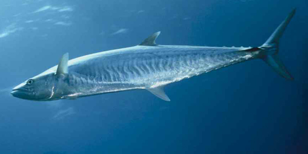
Scomberomorus cavalla, Smoker, kingfishColor of back iridescent bluish green or iron-gray, sides and belly silvery with pale to dusky fins; streamlined body with tapered head; distinguished from Spanish mackerel by the king mackerel’s lateral line, which dips sharply. The anterior dorsal fin on a king mackerel is gray in coloration; young fish often have yellowish spots like those of Spanish mackerel.
King mackerel prefer warm waters, and seldomly enter waters below 68° F. The affinity for warm water and the availability of food result in extensive migrations along the southeastern United States, south in the fall and north in the spring. They are caught as far north as the Gulf of Maine, but more often from Virginia south to Brazil, including the Caribbean and the Gulf of Mexico. King mackerel spawn from April to November, with males maturing between their second and third year, and females between their third and fourth year. Largest of the mackerels, the king mackerel may reach a length of 5.5 feet and weigh 100 pounds. They feed on other migratory fishes, squid, and shrimp, and may be seen leaping out of the water in pursuit of prey.
Regulations


NC, SC, GA, FL
- Season is currently open.
- 3 Bag Limit
- Min. Size: 24 in Fork Length
Notes: Allowed to keep cut-off (damaged) Atlantic king mackerel caught under the recreational bag limit and complies with the minimum size limits.A person who is on a trip that spans more than 24 hours may possess no more than two daily bag limits, provided: such trip is aboard a vessel operating as a charter vessel or headboat; the vessel has two licensed operators aboard; and each passenger is issued and has in possession a receipt issued on behalf of the vessel that verifies the length of the trip.———-Federally Permitted Charter/Headboats: -If a federally permitted vessel fishing in federal waters catches a species that is closed to harvest in federal waters, the vessel is not allowed to retain that fish. -If a federally permitted vessel fishing in state waters catches a species that is closed to harvest in federal waters but open in state waters, the vessel is not allowed to retain that species. -If a federally permitted vessel fishing in federal waters catches a species that is closed to harvest in state waters but open to harvest in federal waters, they may retain that fish if they do not stop to fish in state waters when returning to port. All gear must be stowed.For more information on management of South Atlantic federal fisheries, please visit SAFMC or NOAA Fisheries.To see commercial regulations, download Fish Rules Commercial App for iOS devices or Android devices.
King Mackerel Permit – Northern Zone (NY/RI/CT line to NC/SC line)
- Season is currently open.
- Min. Size: 24 in Fork Length
- 3500 lbs Weight Trip Limit
- Quota: Split Season Zone Commercial ACL- 1892064 lbs Whole Weight
3.3% harvested - Fishing Year: March 1 – Feb 28
Areas
Beaufort 45ft Reef
Beaufort 45 Foot Reef is bounded on the north by 32°07.65′ N. lat.; on the south by 32°06.65′ N. lat.; on the east by 80°28.80′ W. long.; and on the west by 80°29.80′ W. long.Fishing may only be conducted with handline, rod and reel, and spearfishing gear.Use of a sea bass pot or bottom longline is prohibited. Use of a powerhead to take South Atlantic snapper-grouper is prohibited. Possession of a powerhead and a mutilated South Atlantic snapper-grouper in or after having fished in this SMZ constitutes evidence that such fish was taken with a powerhead in the SMZ.Harvest and possession of a South Atlantic snapper-grouper is limited to the bag-limit.All harvest and possession of coastal migratory pelagic fish (King Mackerel, Spanish Mackerel, and Cobia) within the SMZ is limited to the recreational bag limit.
Betsy Ross Reef
Betsy Ross Reef is bounded on the north by 32°03.60′ N. lat.; on the south by 32°02.88′ N. lat.; on the east by 80°24.57′ W. long.; and on the west by 80°25.50′ W. long.Fishing may only be conducted with handline, rod and reel, and spearfishing gear. Use of a sea bass pot or bottom longline is prohibited. Use of a powerhead to take South Atlantic snapper-grouper is prohibited. Possession of a powerhead and a mutilated South Atlantic snapper-grouper in, or after having fished in this SMZ constitutes evidence that such fish was taken with a powerhead in the SMZ.Harvest and possession of a South Atlantic snapper-grouper is limited to the bag-limitAll harvest and possession of coastal migratory pelagic fish (King Mackerel, Spanish Mackerel, and Cobia) within the SMZ is limited to the recreational bag limit.
Bill Perry Jr Reef
Bill Perry Jr. Reef is bounded on the north by 33°26.20′ N. lat.; on the south by 33°25.20′ N. lat.; on the east by 78°32.70′ W. long.; and on the west by 78°33.80′ W. long.Fishing may only be conducted with handline, rod and reel, and spearfishing gear.Use of a sea bass pot or bottom longline is prohibited. Use of a powerhead to take South Atlantic snapper-grouper is prohibited. Possession of a powerhead and a mutilated South Atlantic snapper-grouper in, or after having fished in, this SMZ constitutes evidence that such fish was taken with a powerhead in the SMZ.Harvest and possession of a South Atlantic snapper-grouper is limited to the bag-limit.All harvest and possession of coastal migratory pelagic fish (King Mackerel, Spanish Mackerel, and Cobia) within the SMZ is limited to the recreational bag limit.
Blake Ridge Diapir
In Blake Ridge Diapir no person may:Use a bottom longline, trawl (mid-water or bottom), dredge, pot, or trap.If aboard a fishing vessel, anchor, use an anchor and chain, or use a grapple and chain.Fish for coral or possess coral in or from the Deepwater Coral HAPC on board a fishing vessel.
BP 25 Reef
BP-25 Reef is bounded on the north by 33°21.70′ N. lat.; on the south by 33°20.70′ N. lat.; on the east by 78°24.80′ W. long.; and on the west by 78°25.60′ W. long.Fishing may only be conducted with handline, rod and reel, and spearfishing gear. Use of a sea bass pot or bottom longline is prohibited. Use of a powerhead to take South Atlantic snapper-grouper is prohibited. Possession of a powerhead and a mutilated South Atlantic snapper-grouper in, or after having fished in, this SMZ constitutes evidence that such fish was taken with a powerhead in the SMZ.Harvest and possession of a South Atlantic snapper-grouper is limited to the bag-limits specified §622.187(b).All harvest and possession of coastal migratory pelagic fish (King Mackerel, Spanish Mackerel, and Cobia) within the SMZ is limited to the recreational bag limit.
Cape Fear Lophelia Banks
In Cape Fear Lophelia Banks no person may:Use a bottom longline, trawl (mid-water or bottom), dredge, pot, or trap.If aboard a fishing vessel, anchor, use an anchor and chain, or use a grapple and chain.Fish for coral or possess coral in or from the Deepwater Coral HAPC on board a fishing vessel.
Cape Lookout Lophelia Banks
In Cape Lookout Lophelia Banks no person may:Use a bottom longline, trawl (mid-water or bottom), dredge, pot, or trap.If aboard a fishing vessel, anchor, use an anchor and chain, or use a grapple and chain.Fish for coral or possess coral in or from the Deepwater Coral HAPC on board a fishing vessel.
Cape Romain Reef
Cape Romain Reef is bounded on the north by 33°00.00′ N. lat.; on the south by 32°59.50′ N. lat.; on the east by 79°02.01′ W. long.; and on the west by 79°02.62′ W. long.Fishing may only be conducted with handline, rod and reel, and spearfishing gear.Use of a sea bass pot or bottom longline is prohibited. Use of a powerhead to take South Atlantic snapper-grouper is prohibited. Possession of a powerhead and a mutilated South Atlantic snapper-grouper in, or after having fished in, this SMZ constitutes evidence that such fish was taken with a powerhead in the SMZ.Harvest and possession of a South Atlantic snapper-grouper is limited to the bag limit..All harvest and possession of coastal migratory pelagic fish (King Mackerel, Spanish Mackerel, and Cobia) within the SMZ is limited to the recreational bag limit.
Capers Reef
Capers Reef is bounded on the north by 32°45.45′ N. lat.; on the south by 32°43.91′ N. lat.; on the east by 79°33.81′ W. long.; and on the west by 79°35.10′ W. long.Fishing may only be conducted with handline, rod and reel, and spearfishing gear.Use of a sea bass pot or bottom longline is prohibited. Use of a powerhead to take South Atlantic snapper-grouper is prohibited. Possession of a powerhead and a mutilated South Atlantic snapper-grouper in, or after having fished in, this SMZ constitutes evidence that such fish was taken with a powerhead in the SMZ.Harvest and possession of a South Atlantic snapper-grouper is limited to the bag-limitAll harvest and possession of coastal migratory pelagic fish (King Mackerel, Spanish Mackerel, and Cobia) within the SMZ is limited to the recreational bag limit.
Charleston 60ft Reef
Charleston 60 Foot Reef is bounded on the north by 32°33.60′ N. lat.; on the south by 32°32.60′ N. lat.; on the east by 79°39.70′ W. long.; and on the west by 79°40.90′ W. long.Fishing may only be conducted with handline, rod and reel, and spearfishing gear. Use of a sea bass pot or bottom longline is prohibited. Use of a powerhead to take South Atlantic snapper-grouper is prohibited. Possession of a powerhead and a mutilated South Atlantic snapper-grouper in, or after having fished in, this SMZ constitutes evidence that such fish was taken with a powerhead in the SMZ.Harvest and possession of a South Atlantic snapper-grouper is limited to the bag limit.All harvest and possession of coastal migratory pelagic fish (King Mackerel, Spanish Mackerel, and Cobia) within the SMZ is limited to the recreational bag limit.
CJ Davidson Reef
CJ Davidson Reef is bounded on the north by 33°06.48′ N. lat.; on the south by 33°05.48′ N. lat.; on the east by 79°00.27′ W. long.; and on the west by 79°01.39′ W. long.Fishing may only be conducted with handline, rod and reel, and spearfishing gear. Use of a sea bass pot or bottom longline is prohibited. Use of a powerhead to take South Atlantic snapper-grouper is prohibited. Possession of a powerhead and a mutilated South Atlantic snapper-grouper in, or after having fished in, this SMZ constitutes evidence that such fish was taken with a powerhead in the SMZ.Harvest and possession of a South Atlantic snapper-grouper is limited to the bag limit.All harvest and possession of coastal migratory pelagic fish (King Mackerel, Spanish Mackerel, and Cobia) within the SMZ is limited to the recreational bag limit.
Comanche Reef
Comanche Reef is bounded on the north by 32°27.40′ N. lat.; on the south by 32°26.90′ N. lat.; on the east by 79°18.80′ W. long.; and on the west by 79°19.60′ W. long.Fishing may only be conducted with handline, rod and reel, and spearfishing gear. Use of a sea bass pot or bottom longline is prohibited. Use of a powerhead to take South Atlantic snapper-grouper is prohibited. Possession of a powerhead and a mutilated South Atlantic snapper-grouper in, or after having fished in, this SMZ constitutes evidence that such fish was taken with a powerhead in the SMZ.Harvest and possession of a South Atlantic snapper-grouper is limited to the bag-limits specified §622.187(b).All harvest and possession of coastal migratory pelagic fish (King Mackerel, Spanish Mackerel, and Cobia) within the SMZ is limited to the recreational bag limit.
Devil's Hole Spawning SMZ
Devils Hole SMZ is bounded by rhumb lines connecting, in order, the following points:32° 34.311' N 78° 34.996' W32° 34.311' N 78° 33.220' W32° 32.748' N 78° 33.220' W32° 32.748' N 78° 34.996' WFishing for, possession, and retention of snapper grouper species is prohibited in the Spawning SMZs.Harvest and possession of other species, such as dolphin, mackerel, and tuna, would be allowed as other regulations dictate.Anchoring ProhibitedFishermen are allowed to transit with snapper grouper species onboard their vessel if their fishing gear is stowed according to regulations. Properly stowed means:Terminal gear (i.e., hook, leader, sinker, flasher, or bait) must be disconnected and stowed separately from automatic reel, bandit gear, buoy gear, hand-line, or rod and reel. Rod and reel must be removed from the rod holder and stowed securely on or below deck.Longline may be left on the drum if all gangions and hooks are disconnected and stowed below deck. Hooks cannot be baited. All buoys must be disconnected from the gear: however, buoys can remain on deck.A trawl or try net may remain on deck, but trawl doors must be disconnected from the net and must be secured. Note: This regulation may vary among protected areas and habitat areas of particular concern.A gill net, stab net, or trammel net must be left on the drum. Any additional such nets not attached to the drum must be stowed below deck.A crustacean trap, golden crab trap, or sea bass pot cannot be baited. All buoys must be disconnected from the gear; however, buoys can remain on deck.
Eagles Nest Reef
Eagles Nest Reef is bounded on the north by 32°01.48′ N. lat.; on the south by 32°00.98′ N. lat.; on the east by 80°30.00′ W. long.; and on the west by 80°30.65′ W. long.Fishing may only be conducted with handline, rod and reel, and spearfishing gear. Use of a sea bass pot or bottom longline is prohibited. Use of a powerhead to take South Atlantic snapper-grouper is prohibited. Possession of a powerhead and a mutilated South Atlantic snapper-grouper in, or after having fished in, this SMZ constitutes evidence that such fish was taken with a powerhead in the SMZ.Harvest and possession of a South Atlantic snapper-grouper is limited to the bag limit.All harvest and possession of coastal migratory pelagic fish (King Mackerel, Spanish Mackerel, and Cobia) within the SMZ is limited to the recreational bag limit.
Edisto 40ft Reef
Edisto 40 Foot Reef is bounded on the north by 32°25.78′ N. lat.; on the south by 32°24.78′ N. lat.; on the east by 80°11.24′ W. long.; and on the west by 80°12.32′ W. long.Fishing may only be conducted with handline, rod and reel, and spearfishing gear. Use of a sea bass pot or bottom longline is prohibited. Use of a powerhead to take South Atlantic snapper-grouper is prohibited. Possession of a powerhead and a mutilated South Atlantic snapper-grouper in, or after having fished in, this SMZ constitutes evidence that such fish was taken with a powerhead in the SMZ.Harvest and possession of a South Atlantic snapper-grouper is limited to the bag limit.All harvest and possession of coastal migratory pelagic fish (King Mackerel, Spanish Mackerel, and Cobia) within the SMZ is limited to the recreational bag limit.
Edisto 60ft Reef
Edisto 60 Foot Reef is bounded on the north by 32°21.75′ N. lat.; on the south by 32°20.75′ N. lat.; on the east by 80°04.10′ W. longitude; and on the west by 80°05.70′ W. long.Fishing may only be conducted with handline, rod and reel, and spearfishing gear. Use of a sea bass pot or bottom longline is prohibited. Use of a powerhead to take South Atlantic snapper-grouper is prohibited. Possession of a powerhead and a mutilated South Atlantic snapper-grouper in, or after having fished in, this SMZ constitutes evidence that such fish was taken with a powerhead in the SMZ.Harvest and possession of a South Atlantic snapper-grouper is limited to the bag limit.All harvest and possession of coastal migratory pelagic fish (King Mackerel, Spanish Mackerel, and Cobia) within the SMZ is limited to the recreational bag limit.
Edisto Offshore Reef
Edisto Offshore Reef is bounded on the north by 32°15.30′ N. lat.; on the south by 32°13.90′ N. lat.; on the east by 79°50.25′ W. long.; and on the west by 79°51.45′ W. long.Fishing may only be conducted with handline, rod and reel, and spearfishing gear. Use of a sea bass pot or bottom longline is prohibited. Use of a powerhead to take South Atlantic snapper-grouper is prohibited. Possession of a powerhead and a mutilated South Atlantic snapper-grouper in, or after having fished in, this SMZ constitutes evidence that such fish was taken with a powerhead in the SMZ.Harvest and possession of a South Atlantic snapper-grouper is limited to the bag-limits specified §622.187(b).All harvest and possession of coastal migratory pelagic fish (King Mackerel, Spanish Mackerel, and Cobia) within the SMZ is limited to the recreational bag limit.
EEZ Tortugas North
The area is bounded by rhumb lines connecting the following points: From point A at 24°40′00″ N. lat., 83°06′00″ W. long. to point B at 24°46′00″ N. lat., 83°06′00″ W. long. to point C at 24°46′00″ N. lat., 83°00′00″ W. long.; thence along the line denoting the seaward limit of Florida's waters, as shown on the current edition of NOAA chart 11434, to point A at 24°40′00″ N. lat., 83°06′00″ W. long.Fishing for any species and bottom anchoring by fishing vessels is prohibited year-round.
Florida Middle Grounds
Florida Middle Grounds HAPC is the area bounded by rhumb lines connecting the following points: 28°42.5′ N 84°24.8′ W28°42.5′ N 84°16.3′ W28°11.0′ N 84°00.0′ W28°11.0′ N 84°07.0′ W28°26.6′ N 84°24.8′ W28°42.5′ N 84°24.8′ WDeployment of bottom longline, bottom trawl, dredge, pot, or trap is prohibited year-round.
Fripp Island Reef
Fripp Island Reef is bounded on the north by 32°15.92′ N. lat.; on the south by 32°14.75′ N. lat.; on the east by 80°21.62′ W. long.; and on the west by 80°22.90′ W. long.Fishing may only be conducted with handline, rod and reel, and spearfishing gear. Use of a sea bass pot or bottom longline is prohibited. Use of a powerhead to take South Atlantic snapper-grouper is prohibited. Possession of a powerhead and a mutilated South Atlantic snapper-grouper in, or after having fished in, this SMZ constitutes evidence that such fish was taken with a powerhead in the SMZ.Harvest and possession of a South Atlantic snapper-grouper is limited to the bag-limit.All harvest and possession of coastal migratory pelagic fish (King Mackerel, Spanish Mackerel, and Cobia) within the SMZ is limited to the recreational bag limit.
Ft Pierce Offshore Reef
Ft. Pierce Offshore Reef is bounded by rhumb lines connecting, in order, the following points:27°23.68′ N 80°03.95′ W27°22.80′ N 80°03.60′ W27°23.94′ N 80°00.02′ W27°24.85′ N 80°00.33′ W27°23.68′ N 80°03.95′ WUse of Sea Bass Pot or Bottom Longline ProhibitedUse of powerhead to take South Atlantic Snapper-Grouper prohibitedA hydraulic or electric reel that is permanently affixed to the vessel is prohibited when fishing for South Atlantic Snapper-Grouper
Georgetown 95ft Reef
Georgetown 95 Foot Reef is bounded on the north by 33°11.75′ N. lat.; on the south by 33°10.75′ N. lat.; on the east by 78°24.10′ W. long.; and on the west by 78°25.63′ W. long.Fishing may only be conducted with handline, rod and reel, and spearfishing gear. Use of a sea bass pot or bottom longline is prohibited. Use of a powerhead to take South Atlantic snapper-grouper is prohibited. Possession of a powerhead and a mutilated South Atlantic snapper-grouper in, or after having fished in, this SMZ constitutes evidence that such fish was taken with a powerhead in the SMZ.Harvest and possession of a South Atlantic snapper-grouper is limited to the bag limit.All harvest and possession of coastal migratory pelagic fish (King Mackerel, Spanish Mackerel, and Cobia) within the SMZ is limited to the recreational bag limit.
Georgetown Reef
Georgetown Reef is bounded on the north by 33°14.90′ N. lat.; on the south by 33°13.85′ N. lat.; on the east by 78°59.45′ W. long.; and on the west by 79°00.65′ W. long.Fishing may only be conducted with handline, rod and reel, and spearfishing gear. Use of a sea bass pot or bottom longline is prohibited. Use of a powerhead to take South Atlantic snapper-grouper is prohibited. Possession of a powerhead and a mutilated South Atlantic snapper-grouper in, or after having fished in, this SMZ constitutes evidence that such fish was taken with a powerhead in the SMZ.Harvest and possession of a South Atlantic snapper-grouper is limited to the bag-limit.All harvest and possession of coastal migratory pelagic fish (King Mackerel, Spanish Mackerel, and Cobia) within the SMZ is limited to the recreational bag limit.
Greenville Reef
Greenville Reef is bounded on the north by 32°57.25′ N. lat.; on the south by 32°56.25′ N. lat.; on the east by 78°54.25′ W. long.; and on the west by 78°55.25′ W. long.Fishing may only be conducted with handline, rod and reel, and spearfishing gear. Use of a sea bass pot or bottom longline is prohibited. Use of a powerhead to take South Atlantic snapper-grouper is prohibited. Possession of a powerhead and a mutilated South Atlantic snapper-grouper in, or after having fished in, this SMZ constitutes evidence that such fish was taken with a powerhead in the SMZ.Harvest and possession of a South Atlantic snapper-grouper is limited to the bag limit.All harvest and possession of coastal migratory pelagic fish (King Mackerel, Spanish Mackerel, and Cobia) within the SMZ is limited to the recreational bag limit.
Hilton Head Reef
Hilton Head Reef (Artificial Reef—T) is bounded on the north by 32°00.71′ N. lat.; on the south by 31°59.42′ N. lat.; on the east by 80°35.23′ W. long.; and on the west by 80°36.37′ W. long. Fishing may only be conducted with handline, rod and reel, and spearfishing gear. Use of a sea bass pot or bottom longline is prohibited. All harvest and possession of coastal migratory pelagic fish (King Mackerel, Spanish Mackerel, and Cobia) within the SMZ is limited to the recreational bag limit
Hunting Island Reef
Hunting Island Reef is bounded on the north by 32°13.72′ N. lat.; on the south by 32°12.30′ N. lat.; on the east by 80°19.23′ W. long.; and on the west by 80°21.00′ W. long.Fishing may only be conducted with handline, rod and reel, and spearfishing gear. Use of a sea bass pot or bottom longline is prohibited. Use of a powerhead to take South Atlantic snapper-grouper is prohibited. Possession of a powerhead and a mutilated South Atlantic snapper-grouper in, or after having fished in, this SMZ constitutes evidence that such fish was taken with a powerhead in the SMZ.Harvest and possession of a South Atlantic snapper-grouper is limited to the bag-limitsAll harvest and possession of coastal migratory pelagic fish (King Mackerel, Spanish Mackerel, and Cobia) within the SMZ is limited to the recreational bag limit.
Kiawah Reef
Kiawah Reef is bounded on the north by 32°29.78′ N. lat.; on the south by 32°28.25′ N. lat.; on the east by 79°59.00′ W. long.; and on the west by 80°00.95′ W. long.Fishing may only be conducted with handline, rod and reel, and spearfishing gear. Use of a sea bass pot or bottom longline is prohibited. Use of a powerhead to take South Atlantic snapper-grouper is prohibited. Possession of a powerhead and a mutilated South Atlantic snapper-grouper in, or after having fished in, this SMZ constitutes evidence that such fish was taken with a powerhead in the SMZ.Harvest and possession of a South Atlantic snapper-grouper is limited to the bag-limit.All harvest and possession of coastal migratory pelagic fish (King Mackerel, Spanish Mackerel, and Cobia) within the SMZ is limited to the recreational bag limit.
L&W Pinnacles and Scamp Reef
L & W Pinnacles and Scamp Reef HAPC is bounded by rhumb lines connecting the following points in order: 29°18.595′ 87°48.757′; 29°18.484′ 87°50.688′; 29°19.754′ 87°52.484′; 29°20.401′ 87°51.449′; 29°20.095′ 87°50.933′; 29°20.832′ 87°46.631′; 29°21.473′ 87°46.326′; 29°21.314′ 87°45.535′; 29°22.518′ 87°43.465′; 29°21.144′ 87°42.632′; 29°19.269′ 87°45.525′; 29°18.595′ 87°48.757′.Deployment of a bottom longline, bottom trawl, buoy gear, dredge, pot, or trap, and bottom anchoring by fishing vessels are prohibited year-round in the area of the HAPC.
Little River Offshore Reef
Little River Offshore Reef is bounded on the north by 33°42.10′ N. lat.; on the south by 33°41.10′ N. lat.; on the east by 78°26.40′ W. long.; and on the west by 78°27.10′ W. long.Fishing may only be conducted with handline, rod and reel, and spearfishing gear. Use of a sea bass pot or bottom longline is prohibited.Use of a powerhead to take South Atlantic snapper-grouper is prohibited. Possession of a powerhead and a mutilated South Atlantic snapper-grouper in, or after having fished in, this SMZ constitutes evidence that such fish was taken with a powerhead in the SMZ.Harvest and possession of a South Atlantic snapper-grouper is limited to the bag-limit.All harvest and possession of coastal migratory pelagic fish (King Mackerel, Spanish Mackerel, and Cobia) within the SMZ is limited to the recreational bag limit.
Madison Swanson
The Madison and Swanson sites are bounded by rhumb lines connecting, in order, the following points: 29°17′ 85°50′; 29°17′ 85°38′; 29°06′ 85°38′; 29°06′ 85°50′; 29°17′ 85°50′.Fishing prohibited year-round. Possession of reef fish prohibited even for vessels in transit unless the vessel has an operating vessel monitoring system, a valid federal commercial Gulf of Mexico Reef Fish Permit, and fishing gear is appropriately stowed. These prohibitions do not apply to Atlantic Highly Migratory Species.
Murrels Inlet 60ft Reef
Murrel's Inlet 60 Foot Reef is bounded on the north by 33°17.50′ N. lat.; on the south by 33°16.50′ N. lat.; on the east by 78°44.67′ W. long.; and on the west by 78°45.98′ W. long.Fishing may only be conducted with handline, rod and reel, and spearfishing gear. Use of a sea bass pot or bottom longline is prohibited.Use of a powerhead to take South Atlantic snapper-grouper is prohibited. Possession of a powerhead and a mutilated South Atlantic snapper-grouper in, or after having fished in, this SMZ constitutes evidence that such fish was taken with a powerhead in the SMZ.Harvest and possession of a South Atlantic snapper-grouper is limited to the bag limit.All harvest and possession of coastal migratory pelagic fish (King Mackerel, Spanish Mackerel, and Cobia) within the SMZ is limited to the recreational bag limit.
New Georgetown 60ft Reef
New Georgetown 60 Foot Reef is bounded on the north by 33°09.25′ N. lat.; on the south by 33°07.75′ N. lat.; on the east by 78°49.95′ W. long.; and on the west by 78°51.45′ W. long.Fishing may only be conducted with handline, rod and reel, and spearfishing gear. Use of a sea bass pot or bottom longline is prohibited. Use of a powerhead to take South Atlantic snapper-grouper is prohibited. Possession of a powerhead and a mutilated South Atlantic snapper-grouper in, or after having fished in, this SMZ constitutes evidence that such fish was taken with a powerhead in the SMZ.Harvest and possession of a South Atlantic snapper-grouper is limited to the bag limit.All harvest and possession of coastal migratory pelagic fish (King Mackerel, Spanish Mackerel, and Cobia) within the SMZ is limited to the recreational bag limit.
North Inlet 45ft Reef
North Inlet 45 Foot Reef is bounded on the north by 33°21.03′ N. lat.; on the south by 33°20.03′ N. lat.; on the east by 79°00.31′ W. long.; and on the west by 79°01.51′ W. long.Fishing may only be conducted with handline, rod and reel, and spearfishing gear. Use of a sea bass pot or bottom longline is prohibited. Use of a powerhead to take South Atlantic snapper-grouper is prohibited. Possession of a powerhead and a mutilated South Atlantic snapper-grouper in, or after having fished in, this SMZ constitutes evidence that such fish was taken with a powerhead in the SMZ.Harvest and possession of a South Atlantic snapper-grouper is limited to the bag limit.All harvest and possession of coastal migratory pelagic fish (King Mackerel, Spanish Mackerel, and Cobia) within the SMZ is limited to the recreational bag limit.
Oculina Bank Habitat Area of Particular Concern
In the Oculina Bank HAPC, no person may:Use a bottom longline, bottom trawl, dredge, pot, or trap.If aboard a fishing vessel, anchor, use an anchor and chain, or use a grapple and chain.Fish for or possess rock shrimp in or from the Oculina Bank HAPC, except a shrimp vessel with a valid commercial vessel permit for rock shrimp that possesses rock shrimp may transit through the Oculina Bank HAPC if fishing gear is appropriately stowed. For the purpose of this paragraph, transit means a direct and non-stop continuous course through the area, maintaining a minimum speed of five knots as determined by an operating VMS and a VMS minimum ping rate of 1 ping per 5 minutes; fishing gear appropriately stowed means that doors and nets are out of the water.
Paradise Reef
Paradise Reef is bounded on the north by 33°31.59′ N. lat.; on the south by 33°30.51′ N. lat.; on the east by 78°57.55′ W. long.; and on the west by 78°58.85′ W. long. Fishing may only be conducted with handline, rod and reel, and spearfishing gear. Use of a sea bass pot or bottom longline is prohibited.Use of a powerhead to take South Atlantic snapper-grouper is prohibited. Possession of a powerhead and a mutilated South Atlantic snapper-grouper in, or after having fished in, this SMZ constitutes evidence that such fish was taken with a powerhead in the SMZ.Harvest and possession of a South Atlantic snapper-grouper is limited to the bag-limit.All harvest and possession of coastal migratory pelagic fish (King Mackerel, Spanish Mackerel, and Cobia) within the SMZ is limited to the recreational bag limit.
Pawley's Island Reef
Pawleys Island Reef is bounded on the north by 33°26.58′ N. lat.; on the south by 33°25.76′ N. lat.; on the east by 79°00.29′ W. long.; and on the west by 79°01.24′ W. long.Fishing may only be conducted with handline, rod and reel, and spearfishing gear. Use of a sea bass pot or bottom longline is prohibited. Use of a powerhead to take South Atlantic snapper-grouper is prohibited. Possession of a powerhead and a mutilated South Atlantic snapper-grouper in, or after having fished in, this SMZ constitutes evidence that such fish was taken with a powerhead in the SMZ.Harvest and possession of a South Atlantic snapper-grouper is limited to the bag-limit.All harvest and possession of coastal migratory pelagic fish (King Mackerel, Spanish Mackerel, and Cobia) within the SMZ is limited to the recreational bag limit.
Pourtales Terrace
No person may:Use a bottom longline, trawl (mid-water or bottom), dredge, pot, or trap.If aboard a fishing vessel, anchor, use an anchor and chain, or use a grapple and chain.Fish for coral or possess coral in or from the Deepwater Coral HAPC on board a fishing vessel.
Pulley Ridge
Pulley Ridge HAPC is bounded by rhumb lines connecting the following points: A 24°58′18″ 83°38′33″; B 24°58′18″ 83°37′00″; C 24°41′11″ 83°37′00″; D 24°40′00″ 83°41′22″; E 24°43′55″ 83°47′15″; A 24°58′18″ 83°38′33″.Deployment of bottom longline, bottom trawl, buoy gear, pot, or trap and bottom anchoring by fishing vessels is prohibited year-round.
Pulley Ridge South Portion A
Pulley Ridge South Portion A HAPC is bounded by rhumb lines connecting the following points in order: 24°40.000′ 83°41.366′; 24°39.666′ 83°42.648′; 24°47.555′ 83°55.240′; 24°57.065′ 83°48.405′; 24°52.859′ 83°41.841′; 24°43.917′ 83°47.250′; 24°40.000′ 83°41.366′.Deployment of a bottom trawl, buoy gear, dredge, pot, or trap, and bottom anchoring by fishing vessels are prohibited year-round in the HAPC.
Roughtounge Reef
Roughtongue Reef HAPC is bounded by rhumb lines connecting the following points in order: 29°27.596′ 87°37.527′; 29°27.621′ 87°31.552′; 29°25.007′ 87°31.539′; 29°24.981′ 87°37.510′; 29°27.596′ 87°37.527′.Deployment of a bottom longline, bottom trawl, buoy gear, dredge, pot, or trap, and bottom anchoring by fishing vessels are prohibited year-round in the HAPC.
Shrimp Access Area 1
Shrimp Access Area 1 is bounded by rhumb lines connecting, in order, the following points: Origin30°06′30″ 80°02′2.4″; A 30°06′30″ 80°05′39.6″; B 30°03′00″ 80°09′30″; C 30°03′00″ 80°06′00″; D 30°04′00″80°02′45.6″; E 29°59′16″ 80°04′11″; F 29°49′12″ 80°05′44″; G 29°43′59″ 80°06′24″; H 29°38′37″ 80°06′53″; I 29°36′54″ 80°07′18″; J 29°31′59″80°07′32″; K 29°29′14″ 80°07′18″; L 29°21′48″ 80°05′01″; M 29°20′25″ 80°04′29″; N 29°20′25″ 80°03′11″; O 29°21′48″ 80°03′52″; P 29°29′14″ 80°06′08″; Q 29°31′59″ 80°06′23″; R 29°36′54″ 80°06′00″; S 29°38′37″ 80°05′43″; T 29°43′59″ 80°05′14″; U 29°49′12″ 80°04′35″; V 29°59′16″ 80°03′01″; W 30°06′30″ 80°00′53″; Origin 30°06′30″ 80°02′2.4″Within the Shrimp Fishery Access Areas in the Stetson-Miami Terrace CHAPC fishing with a shrimp trawl and/or shrimp possession is allowed by any vessel holding a rock shrimp limited access endorsement and equipped with an approved vessel monitoring system (VMS). Otherwise no person may:Use a bottom longline, trawl (mid-water or bottom), dredge, pot, or trap.If aboard a fishing vessel, anchor, use an anchor and chain, or use a grapple and chain.Fish for coral or possess coral in or from the Deepwater Coral HAPC on board a fishing vessel.
Shrimp Access Area 2
Shrimp Access Area 2 is bounded by rhumb lines connecting, in order, the following points: Origin 29°08′00″ 79°59′43″; A 29°06′56″ 79°59′07″; B 29°05′59″ 79°58′44″; C 29°03′34″ 79°57′37″; D 29°02′11″ 79°56′59″; E 29°00′00″ 79°55′32″; F 28°56′55″ 79°54′22″; G 28°55′00″79°53′31″; H 28°53′35″ 79°52′51″; I 28°51′47″79°52′07″; J 28°50′25″ 79°51′27″; K 28°49′53″ 79°51′20″; L 28°49′01″ 79°51′20″; M 28°48′19″ 79°51′10″; N 28°47′13″ 79°50′59″; O 28°43′30″ 79°50′36″; P 28°41′05″ 79°50′04″; Q 28°40′27″ 79°50′07″; R 28°39′50″ 79°49′56″; S 28°39′04″79°49′58″; T 28°36′43″ 79°49′35″; U 28°35′01″ 79°49′24″; V 28°30′37″ 79°48′35″; W 28°30′37″ 79°47′27″; X 28°35′01″ 79°48′16″; Y 28°36′43″ 79°48′27″; Z 28°39′04″ 79°48′50″; AA 28°39′50″ 79°48′48″; AB 28°40′27″ 79°48′58″; AC 28°41′05″ 79°48′56″; AD 28°43′30″ 79°49′28″; AE 28°47′13″ 79°49′51″; AF 28°48′19″ 79°50′01″; AG 28°49′01″ 79°50′13″; AH 28°49′53″ 79°50′12″; AI 28°50′25″ 79°50′17″; AJ 28°51′47″ 79°50′58″; AK 28°53′35″ 79°51′43″; AL 28°55′00″ 79°52′22″; AM 28°56′55″ 79°53′14″; AN 29°00′00″ 79°54′24″; AO 29°02′11″ 79°55′50″; AP 29°03′34″ 79°56′29″; AQ 29°05′59″ 79°57′35″; AR 29°06′56″ 79°57′59″; AS 29°08′00″ 79°58′34″; Origin 29°08′00″ 79°59′43″.Within the Shrimp Fishery Access Areas in the Stetson-Miami Terrace CHAPC fishing with a shrimp trawl and/or shrimp possession is allowed by any vessel holding a rock shrimp limited access endorsement and equipped with an approved vessel monitoring system (VMS). Otherwise no person may:Use a bottom longline, trawl (mid-water or bottom), dredge, pot, or trap.If aboard a fishing vessel, anchor, use an anchor and chain, or use a grapple and chain.Fish for coral or possess coral in or from the Deepwater Coral HAPC on board a fishing vessel.
Shrimp Access Area 3
Shrimp Access Area 3 is bounded by rhumb lines connecting, in order, the following points: Origin 28°14′00″ 79°46′20″; A 28°11′41″ 79°46′12″; B 28°08′02″ 79°45′45″; C 28°01′20″ 79°45′20″; D 27°58′13″ 79°44′51″; E 27°56′23″ 79°44′53″; F 27°49′40″ 79°44′25″; G 27°46′27″ 79°44′22″; H 27°42′00″ 79°44′33″; I 27°36′08″ 79°44′58″; J 27°30′00″ 79°45′29″; K 27°29′04″ 79°45′47″; L 27°27′05″ 79°45′54″; M 27°25′47″ 79°45′57″; N 27°19′46″ 79°45′14″; O 27°17′54″ 79°45′12″; P 27°12′28″ 79°45′00″; Q 27°07′45″ 79°46′07″; R 27°04′47″ 79°46′29″; S 27°00′43″ 79°46′39″; T 26°58′43″ 79°46′28″; U 26°57′06″ 79°46′32″; V 26°57′06″ 79°44′52″; W 26°58′43″ 79°44′47″; X 27°00′43″ 79°44′58″; Y 27°04′47″ 79°44′48″; Z 27°07′45″ 79°44′26″; AA 27°12′28″ 79°43′19″; AB 27°17′54″ 79°43′31″; AC 27°19′46″ 79°43′33″; AD 27°25′47″ 79°44′15″; AE 27°27′05″ 79°44′12″; AF 27°29′04″ 79°44′06″; AG 27°30′00″ 79°43′48″; AH 27°30′00″ 79°44′22″; AI 27°36′08″ 79°43′50″; AJ 27°42′00″ 79°43′25″; AK 27°46′27″ 79°43′14″; AL 27°49′40″ 79°43′17″; AM 27°56′23″ 79°43′45″; AN 27°58′13″ 79°43′43″; AO 28°01′20″ 79°44′11″; AP 28°04′42″ 79°44′25″; AQ 28°08′02″ 79°44′37″; AR 28°11′41″ 79°45′04″; AS 28°14′00″ 79°45′12″; Origin 28°14′00″ 79°46′20″.Within the Shrimp Fishery Access Areas in the Stetson-Miami Terrace CHAPC fishing with a shrimp trawl and/or shrimp possession is allowed by any vessel holding a rock shrimp limited access endorsement and equipped with an approved vessel monitoring system (VMS). Otherwise no person may:Use a bottom longline, trawl (mid-water or bottom), dredge, pot, or trap.If aboard a fishing vessel, anchor, use an anchor and chain, or use a grapple and chain.Fish for coral or possess coral in or from the Deepwater Coral HAPC on board a fishing vessel.
Shrimp Access Area 4
Shrimp Access Area 4 is bounded by rhumb lines connecting, in order, the following points: Origin 26°49′58″ 79°46′54″; A 26°48′58″ 79°46′56″; B 26°47′01″ 79°47′09″; C 26°46′04″ 79°47′09″; D 26°35′09″ 79°48′01″; E 26°33′37″ 79°48′21″; F 26°27′56″ 79°49′09″; G 26°25′55″ 79°49′30″; H 26°21′05″ 79°50′03″; I 26°20′30″ 79°50′20″; J 26°18′56″ 79°50′17″; K 26°18′56″ 79°48′37″; L 26°20′30″ 79°48′40″; M 26°21′05″ 79°48′08″; N 26°25′55″ 79°47′49″; O 26°27′56″ 79°47′29″; P 26°33′37″ 79°46′40″; Q 26°35′09″ 79°46′20″; R 26°46′04″ 79°45′28″; S 26°47′01″ 79°45′28″; T 26°48′58″ 79°45′15″; U 26°49′58″ 79°45′13″; Origin 26°49′58″ 79°46′54″.Within the Shrimp Fishery Access Areas in the Stetson-Miami Terrace CHAPC fishing with a shrimp trawl and/or shrimp possession is allowed by any vessel holding a rock shrimp limited access endorsement and equipped with an approved vessel monitoring system (VMS). Otherwise no person may:Use a bottom longline, trawl (mid-water or bottom), dredge, pot, or trap.If aboard a fishing vessel, anchor, use an anchor and chain, or use a grapple and chain.Fish for coral or possess coral in or from the Deepwater Coral HAPC on board a fishing vessel.
South Cape Lookout Spawning SMZ
South Cape Lookout SMZ is bounded by rhumb lines connecting, in order, the following points: 33° 53.040' 76° 28.617'; 33° 52.019' 76° 27.798'; 33° 49.946' 76° 30.627'; 33° 51.041' 76° 31.424'.Fishing for, possession, and retention of snapper grouper species is prohibited in the Spawning SMZs.Harvest and possession of other species, such as dolphin, mackerel, and tuna, would be allowed as other regulations dictate.Anchoring ProhibitedFishermen are allowed to transit with snapper grouper species onboard their vessel if their fishing gear is stowed according to regulations. Properly stowed means:Terminal gear (i.e., hook, leader, sinker, flasher, or bait) must be disconnected and stowed separately from automatic reel, bandit gear, buoy gear, hand-line, or rod and reel. Rod and reel must be removed from the rod holder and stowed securely on or below deck.Longline may be left on the drum if all gangions and hooks are disconnected and stowed below deck. Hooks cannot be baited. All buoys must be disconnected from the gear: however, buoys can remain on deck.A trawl or try net may remain on deck, but trawl doors must be disconnected from the net and must be secured. Note: This regulation may vary among protected areas and habitat areas of particular concern.A gill net, stab net, or trammel net must be left on the drum. Any additional such nets not attached to the drum must be stowed below deck.A crustacean trap, golden crab trap, or sea bass pot cannot be baited. All buoys must be disconnected from the gear; however, buoys can remain on deck.
Steamboat Lumps
Steamboat Lumps is bounded by rhumb lines connecting, in order, the following points: 28°14′ 84°48′; 28°14′ 84°37′; 28°03′ 84°37′; 28°03′ 84°48′'; 28°14′ 84°48′.Possession of Reef Fish prohibited year-round, except when in transit with fishing gear stowed. Possession of all fish is prohibited November through April, except when in transit with fishing gear stowed. All Fishing Prohibited with the exception of surface trawling which is allowed May through October.
Stetson-Miami Terrace
No person may:Use a bottom longline, trawl (mid-water or bottom), dredge, pot, or trap.If aboard a fishing vessel, anchor, use an anchor and chain, or use a grapple and chain.Fish for coral or possess coral in or from the Deepwater Coral HAPC on board a fishing vessel.
Ten Mile Reef
Ten Mile Reef is bounded on the north by 33°26.65′ N. lat.; on the south by 33°24.80′ N. lat.; on the east by 78°51.08′ W. long.; and on the west by 78°52.97′ W. long. Fishing may only be conducted with handline, rod and reel, and spearfishing gear.Use of a sea bass pot or bottom longline is prohibited. Use of a powerhead to take South Atlantic snapper-grouper is prohibited. Possession of a powerhead and a mutilated South Atlantic snapper-grouper in, or after having fished in, this SMZ constitutes evidence that such fish was taken with a powerhead in the SMZ.Harvest and possession of a South Atlantic snapper-grouper is limited to the bag-limit.All harvest and possession of coastal migratory pelagic fish (King Mackerel, Spanish Mackerel, and Cobia) within the SMZ is limited to the recreational bag limit.
The Edges
The Edges is bounded by rhumb lines connecting, in order, the following points: 28°51′ 85°16′; 28°51′ 85°04′; 28°14′ 84°42′; 28°14′ 84°54′; 28°51′ 85°16′.All fishing prohibited January through April. Possession of any fish species is prohibited January through April, except when in transit with fishing gear stowed.
Tortugas South
Tortugas South area is bounded by rhumb lines connecting, in order, the following points: 24°33′00″ 83°09′00″; 24°33′00″ 83°05′00″; 24°18′00″ 83°05′00″; 24°18′00″ 83°09′00″; 24°33′00″ 83°09′00″.Fishing for any species and bottom anchoring by fishing vessels is prohibited year-round.
Vermilion Reef
Vermilion Reef is bounded on the north by 32°57.80′ N. lat.; on the south by 32°57.30′ N. lat.; on the east by 78°39.30′ W. long.; and on the west by 78°40.10′ W. long.Fishing may only be conducted with handline, rod and reel, and spearfishing gear.Use of a sea bass pot or bottom longline is prohibited. Use of a powerhead to take South Atlantic snapper-grouper is prohibited. Possession of a powerhead and a mutilated South Atlantic snapper-grouper in, or after having fished in, this SMZ constitutes evidence that such fish was taken with a powerhead in the SMZ.Harvest and possession of a South Atlantic snapper-grouper is limited to the bag limit.All harvest and possession of coastal migratory pelagic fish (King Mackerel, Spanish Mackerel, and Cobia) within the SMZ is limited to the recreational bag limit.
Warsaw Hole SMZ
Warsaw Hole SMZ is bounded by rhumb lines connecting, in order, the following points: 24° 22.277' 82° 20.417'; 24° 22.277' 82° 18.215'; 24° 20.932' 82° 18.215' 24° 20.932' 82° 20.417'.Fishing for, possession, and retention of snapper grouper species is prohibited in the Spawning SMZs. Harvest and possession of other species, such as dolphin, mackerel, and tuna, would be allowed as other regulations dictate.Anchoring prohibited.Fishermen are allowed to transit with snapper grouper species onboard their vessel if their fishing gear is stowed according to regulations. Properly stowed means:Terminal gear (i.e., hook, leader, sinker, flasher, or bait) must be disconnected and stowed separately from automatic reel, bandit gear, buoy gear, hand-line, or rod and reel. Rod and reel must be removed from the rod holder and stowed securely on or below deck.Longline may be left on the drum if all gangions and hooks are disconnected and stowed below deck. Hooks cannot be baited. All buoys must be disconnected from the gear: however, buoys can remain on deck.A trawl or try net may remain on deck, but trawl doors must be disconnected from the net and must be secured. Note: This regulation may vary among protected areas and habitat areas of particular concern.A gill net, stab net, or trammel net must be left on the drum. Any additional such nets not attached to the drum must be stowed below deck.A crustacean trap, golden crab trap, or sea bass pot cannot be baited. All buoys must be disconnected from the gear; however, buoys can remain on deck.
West Florida Wall
West Florida Wall HAPC is bounded by rhumb lines connecting the following points in order: 26°28.835′ 84°47.955′; 26°28.816′ 84°46.754′; 26°10.471′ 84°42.076′; 26°10.528′ 84°44.577′; 26°25.028′ 84°47.986′; 26°25.100′ 84°47.980′; 26°28.835′ 84°47.955′.Deployment of bottom-tending gear (bottom longline, bottom trawl, buoy gear, dredge, pot or trap) and bottom anchoring by fishing vessels is prohibited year-round.
King Mackerel Permit – South of the Flagler/Volusia line to the Volusia/Brevard line
- Season is currently open.
- Min. Size: 24 in Fork Length
- 3500 lbs Whole Weight Trip Limit
- Quota: Split Season Zone Commercial ACL- 2528008 lbs Weight
15% harvested - Fishing Year: Mar 1 – Sept 30
Notes: Season 1: March 1– September 30, Season 2: October 1 – February 28.ACL listed by season. Season closes once ACL is met.
Areas
Beaufort 45ft Reef
Beaufort 45 Foot Reef is bounded on the north by 32°07.65′ N. lat.; on the south by 32°06.65′ N. lat.; on the east by 80°28.80′ W. long.; and on the west by 80°29.80′ W. long.Fishing may only be conducted with handline, rod and reel, and spearfishing gear.Use of a sea bass pot or bottom longline is prohibited. Use of a powerhead to take South Atlantic snapper-grouper is prohibited. Possession of a powerhead and a mutilated South Atlantic snapper-grouper in or after having fished in this SMZ constitutes evidence that such fish was taken with a powerhead in the SMZ.Harvest and possession of a South Atlantic snapper-grouper is limited to the bag-limit.All harvest and possession of coastal migratory pelagic fish (King Mackerel, Spanish Mackerel, and Cobia) within the SMZ is limited to the recreational bag limit.
Betsy Ross Reef
Betsy Ross Reef is bounded on the north by 32°03.60′ N. lat.; on the south by 32°02.88′ N. lat.; on the east by 80°24.57′ W. long.; and on the west by 80°25.50′ W. long.Fishing may only be conducted with handline, rod and reel, and spearfishing gear. Use of a sea bass pot or bottom longline is prohibited. Use of a powerhead to take South Atlantic snapper-grouper is prohibited. Possession of a powerhead and a mutilated South Atlantic snapper-grouper in, or after having fished in this SMZ constitutes evidence that such fish was taken with a powerhead in the SMZ.Harvest and possession of a South Atlantic snapper-grouper is limited to the bag-limitAll harvest and possession of coastal migratory pelagic fish (King Mackerel, Spanish Mackerel, and Cobia) within the SMZ is limited to the recreational bag limit.
Bill Perry Jr Reef
Bill Perry Jr. Reef is bounded on the north by 33°26.20′ N. lat.; on the south by 33°25.20′ N. lat.; on the east by 78°32.70′ W. long.; and on the west by 78°33.80′ W. long.Fishing may only be conducted with handline, rod and reel, and spearfishing gear.Use of a sea bass pot or bottom longline is prohibited. Use of a powerhead to take South Atlantic snapper-grouper is prohibited. Possession of a powerhead and a mutilated South Atlantic snapper-grouper in, or after having fished in, this SMZ constitutes evidence that such fish was taken with a powerhead in the SMZ.Harvest and possession of a South Atlantic snapper-grouper is limited to the bag-limit.All harvest and possession of coastal migratory pelagic fish (King Mackerel, Spanish Mackerel, and Cobia) within the SMZ is limited to the recreational bag limit.
Blake Ridge Diapir
In Blake Ridge Diapir no person may:Use a bottom longline, trawl (mid-water or bottom), dredge, pot, or trap.If aboard a fishing vessel, anchor, use an anchor and chain, or use a grapple and chain.Fish for coral or possess coral in or from the Deepwater Coral HAPC on board a fishing vessel.
BP 25 Reef
BP-25 Reef is bounded on the north by 33°21.70′ N. lat.; on the south by 33°20.70′ N. lat.; on the east by 78°24.80′ W. long.; and on the west by 78°25.60′ W. long.Fishing may only be conducted with handline, rod and reel, and spearfishing gear. Use of a sea bass pot or bottom longline is prohibited. Use of a powerhead to take South Atlantic snapper-grouper is prohibited. Possession of a powerhead and a mutilated South Atlantic snapper-grouper in, or after having fished in, this SMZ constitutes evidence that such fish was taken with a powerhead in the SMZ.Harvest and possession of a South Atlantic snapper-grouper is limited to the bag-limits specified §622.187(b).All harvest and possession of coastal migratory pelagic fish (King Mackerel, Spanish Mackerel, and Cobia) within the SMZ is limited to the recreational bag limit.
Cape Fear Lophelia Banks
In Cape Fear Lophelia Banks no person may:Use a bottom longline, trawl (mid-water or bottom), dredge, pot, or trap.If aboard a fishing vessel, anchor, use an anchor and chain, or use a grapple and chain.Fish for coral or possess coral in or from the Deepwater Coral HAPC on board a fishing vessel.
Cape Lookout Lophelia Banks
In Cape Lookout Lophelia Banks no person may:Use a bottom longline, trawl (mid-water or bottom), dredge, pot, or trap.If aboard a fishing vessel, anchor, use an anchor and chain, or use a grapple and chain.Fish for coral or possess coral in or from the Deepwater Coral HAPC on board a fishing vessel.
Cape Romain Reef
Cape Romain Reef is bounded on the north by 33°00.00′ N. lat.; on the south by 32°59.50′ N. lat.; on the east by 79°02.01′ W. long.; and on the west by 79°02.62′ W. long.Fishing may only be conducted with handline, rod and reel, and spearfishing gear.Use of a sea bass pot or bottom longline is prohibited. Use of a powerhead to take South Atlantic snapper-grouper is prohibited. Possession of a powerhead and a mutilated South Atlantic snapper-grouper in, or after having fished in, this SMZ constitutes evidence that such fish was taken with a powerhead in the SMZ.Harvest and possession of a South Atlantic snapper-grouper is limited to the bag limit..All harvest and possession of coastal migratory pelagic fish (King Mackerel, Spanish Mackerel, and Cobia) within the SMZ is limited to the recreational bag limit.
Capers Reef
Capers Reef is bounded on the north by 32°45.45′ N. lat.; on the south by 32°43.91′ N. lat.; on the east by 79°33.81′ W. long.; and on the west by 79°35.10′ W. long.Fishing may only be conducted with handline, rod and reel, and spearfishing gear.Use of a sea bass pot or bottom longline is prohibited. Use of a powerhead to take South Atlantic snapper-grouper is prohibited. Possession of a powerhead and a mutilated South Atlantic snapper-grouper in, or after having fished in, this SMZ constitutes evidence that such fish was taken with a powerhead in the SMZ.Harvest and possession of a South Atlantic snapper-grouper is limited to the bag-limitAll harvest and possession of coastal migratory pelagic fish (King Mackerel, Spanish Mackerel, and Cobia) within the SMZ is limited to the recreational bag limit.
Charleston 60ft Reef
Charleston 60 Foot Reef is bounded on the north by 32°33.60′ N. lat.; on the south by 32°32.60′ N. lat.; on the east by 79°39.70′ W. long.; and on the west by 79°40.90′ W. long.Fishing may only be conducted with handline, rod and reel, and spearfishing gear. Use of a sea bass pot or bottom longline is prohibited. Use of a powerhead to take South Atlantic snapper-grouper is prohibited. Possession of a powerhead and a mutilated South Atlantic snapper-grouper in, or after having fished in, this SMZ constitutes evidence that such fish was taken with a powerhead in the SMZ.Harvest and possession of a South Atlantic snapper-grouper is limited to the bag limit.All harvest and possession of coastal migratory pelagic fish (King Mackerel, Spanish Mackerel, and Cobia) within the SMZ is limited to the recreational bag limit.
CJ Davidson Reef
CJ Davidson Reef is bounded on the north by 33°06.48′ N. lat.; on the south by 33°05.48′ N. lat.; on the east by 79°00.27′ W. long.; and on the west by 79°01.39′ W. long.Fishing may only be conducted with handline, rod and reel, and spearfishing gear. Use of a sea bass pot or bottom longline is prohibited. Use of a powerhead to take South Atlantic snapper-grouper is prohibited. Possession of a powerhead and a mutilated South Atlantic snapper-grouper in, or after having fished in, this SMZ constitutes evidence that such fish was taken with a powerhead in the SMZ.Harvest and possession of a South Atlantic snapper-grouper is limited to the bag limit.All harvest and possession of coastal migratory pelagic fish (King Mackerel, Spanish Mackerel, and Cobia) within the SMZ is limited to the recreational bag limit.
Comanche Reef
Comanche Reef is bounded on the north by 32°27.40′ N. lat.; on the south by 32°26.90′ N. lat.; on the east by 79°18.80′ W. long.; and on the west by 79°19.60′ W. long.Fishing may only be conducted with handline, rod and reel, and spearfishing gear. Use of a sea bass pot or bottom longline is prohibited. Use of a powerhead to take South Atlantic snapper-grouper is prohibited. Possession of a powerhead and a mutilated South Atlantic snapper-grouper in, or after having fished in, this SMZ constitutes evidence that such fish was taken with a powerhead in the SMZ.Harvest and possession of a South Atlantic snapper-grouper is limited to the bag-limits specified §622.187(b).All harvest and possession of coastal migratory pelagic fish (King Mackerel, Spanish Mackerel, and Cobia) within the SMZ is limited to the recreational bag limit.
Devil's Hole Spawning SMZ
Devils Hole SMZ is bounded by rhumb lines connecting, in order, the following points:32° 34.311' N 78° 34.996' W32° 34.311' N 78° 33.220' W32° 32.748' N 78° 33.220' W32° 32.748' N 78° 34.996' WFishing for, possession, and retention of snapper grouper species is prohibited in the Spawning SMZs.Harvest and possession of other species, such as dolphin, mackerel, and tuna, would be allowed as other regulations dictate.Anchoring ProhibitedFishermen are allowed to transit with snapper grouper species onboard their vessel if their fishing gear is stowed according to regulations. Properly stowed means:Terminal gear (i.e., hook, leader, sinker, flasher, or bait) must be disconnected and stowed separately from automatic reel, bandit gear, buoy gear, hand-line, or rod and reel. Rod and reel must be removed from the rod holder and stowed securely on or below deck.Longline may be left on the drum if all gangions and hooks are disconnected and stowed below deck. Hooks cannot be baited. All buoys must be disconnected from the gear: however, buoys can remain on deck.A trawl or try net may remain on deck, but trawl doors must be disconnected from the net and must be secured. Note: This regulation may vary among protected areas and habitat areas of particular concern.A gill net, stab net, or trammel net must be left on the drum. Any additional such nets not attached to the drum must be stowed below deck.A crustacean trap, golden crab trap, or sea bass pot cannot be baited. All buoys must be disconnected from the gear; however, buoys can remain on deck.
Eagles Nest Reef
Eagles Nest Reef is bounded on the north by 32°01.48′ N. lat.; on the south by 32°00.98′ N. lat.; on the east by 80°30.00′ W. long.; and on the west by 80°30.65′ W. long.Fishing may only be conducted with handline, rod and reel, and spearfishing gear. Use of a sea bass pot or bottom longline is prohibited. Use of a powerhead to take South Atlantic snapper-grouper is prohibited. Possession of a powerhead and a mutilated South Atlantic snapper-grouper in, or after having fished in, this SMZ constitutes evidence that such fish was taken with a powerhead in the SMZ.Harvest and possession of a South Atlantic snapper-grouper is limited to the bag limit.All harvest and possession of coastal migratory pelagic fish (King Mackerel, Spanish Mackerel, and Cobia) within the SMZ is limited to the recreational bag limit.
Edisto 40ft Reef
Edisto 40 Foot Reef is bounded on the north by 32°25.78′ N. lat.; on the south by 32°24.78′ N. lat.; on the east by 80°11.24′ W. long.; and on the west by 80°12.32′ W. long.Fishing may only be conducted with handline, rod and reel, and spearfishing gear. Use of a sea bass pot or bottom longline is prohibited. Use of a powerhead to take South Atlantic snapper-grouper is prohibited. Possession of a powerhead and a mutilated South Atlantic snapper-grouper in, or after having fished in, this SMZ constitutes evidence that such fish was taken with a powerhead in the SMZ.Harvest and possession of a South Atlantic snapper-grouper is limited to the bag limit.All harvest and possession of coastal migratory pelagic fish (King Mackerel, Spanish Mackerel, and Cobia) within the SMZ is limited to the recreational bag limit.
Edisto 60ft Reef
Edisto 60 Foot Reef is bounded on the north by 32°21.75′ N. lat.; on the south by 32°20.75′ N. lat.; on the east by 80°04.10′ W. longitude; and on the west by 80°05.70′ W. long.Fishing may only be conducted with handline, rod and reel, and spearfishing gear. Use of a sea bass pot or bottom longline is prohibited. Use of a powerhead to take South Atlantic snapper-grouper is prohibited. Possession of a powerhead and a mutilated South Atlantic snapper-grouper in, or after having fished in, this SMZ constitutes evidence that such fish was taken with a powerhead in the SMZ.Harvest and possession of a South Atlantic snapper-grouper is limited to the bag limit.All harvest and possession of coastal migratory pelagic fish (King Mackerel, Spanish Mackerel, and Cobia) within the SMZ is limited to the recreational bag limit.
Edisto Offshore Reef
Edisto Offshore Reef is bounded on the north by 32°15.30′ N. lat.; on the south by 32°13.90′ N. lat.; on the east by 79°50.25′ W. long.; and on the west by 79°51.45′ W. long.Fishing may only be conducted with handline, rod and reel, and spearfishing gear. Use of a sea bass pot or bottom longline is prohibited. Use of a powerhead to take South Atlantic snapper-grouper is prohibited. Possession of a powerhead and a mutilated South Atlantic snapper-grouper in, or after having fished in, this SMZ constitutes evidence that such fish was taken with a powerhead in the SMZ.Harvest and possession of a South Atlantic snapper-grouper is limited to the bag-limits specified §622.187(b).All harvest and possession of coastal migratory pelagic fish (King Mackerel, Spanish Mackerel, and Cobia) within the SMZ is limited to the recreational bag limit.
EEZ Tortugas North
The area is bounded by rhumb lines connecting the following points: From point A at 24°40′00″ N. lat., 83°06′00″ W. long. to point B at 24°46′00″ N. lat., 83°06′00″ W. long. to point C at 24°46′00″ N. lat., 83°00′00″ W. long.; thence along the line denoting the seaward limit of Florida's waters, as shown on the current edition of NOAA chart 11434, to point A at 24°40′00″ N. lat., 83°06′00″ W. long.Fishing for any species and bottom anchoring by fishing vessels is prohibited year-round.
Florida Middle Grounds
Florida Middle Grounds HAPC is the area bounded by rhumb lines connecting the following points: 28°42.5′ N 84°24.8′ W28°42.5′ N 84°16.3′ W28°11.0′ N 84°00.0′ W28°11.0′ N 84°07.0′ W28°26.6′ N 84°24.8′ W28°42.5′ N 84°24.8′ WDeployment of bottom longline, bottom trawl, dredge, pot, or trap is prohibited year-round.
Fripp Island Reef
Fripp Island Reef is bounded on the north by 32°15.92′ N. lat.; on the south by 32°14.75′ N. lat.; on the east by 80°21.62′ W. long.; and on the west by 80°22.90′ W. long.Fishing may only be conducted with handline, rod and reel, and spearfishing gear. Use of a sea bass pot or bottom longline is prohibited. Use of a powerhead to take South Atlantic snapper-grouper is prohibited. Possession of a powerhead and a mutilated South Atlantic snapper-grouper in, or after having fished in, this SMZ constitutes evidence that such fish was taken with a powerhead in the SMZ.Harvest and possession of a South Atlantic snapper-grouper is limited to the bag-limit.All harvest and possession of coastal migratory pelagic fish (King Mackerel, Spanish Mackerel, and Cobia) within the SMZ is limited to the recreational bag limit.
Ft Pierce Offshore Reef
Ft. Pierce Offshore Reef is bounded by rhumb lines connecting, in order, the following points:27°23.68′ N 80°03.95′ W27°22.80′ N 80°03.60′ W27°23.94′ N 80°00.02′ W27°24.85′ N 80°00.33′ W27°23.68′ N 80°03.95′ WUse of Sea Bass Pot or Bottom Longline ProhibitedUse of powerhead to take South Atlantic Snapper-Grouper prohibitedA hydraulic or electric reel that is permanently affixed to the vessel is prohibited when fishing for South Atlantic Snapper-Grouper
Georgetown 95ft Reef
Georgetown 95 Foot Reef is bounded on the north by 33°11.75′ N. lat.; on the south by 33°10.75′ N. lat.; on the east by 78°24.10′ W. long.; and on the west by 78°25.63′ W. long.Fishing may only be conducted with handline, rod and reel, and spearfishing gear. Use of a sea bass pot or bottom longline is prohibited. Use of a powerhead to take South Atlantic snapper-grouper is prohibited. Possession of a powerhead and a mutilated South Atlantic snapper-grouper in, or after having fished in, this SMZ constitutes evidence that such fish was taken with a powerhead in the SMZ.Harvest and possession of a South Atlantic snapper-grouper is limited to the bag limit.All harvest and possession of coastal migratory pelagic fish (King Mackerel, Spanish Mackerel, and Cobia) within the SMZ is limited to the recreational bag limit.
Georgetown Reef
Georgetown Reef is bounded on the north by 33°14.90′ N. lat.; on the south by 33°13.85′ N. lat.; on the east by 78°59.45′ W. long.; and on the west by 79°00.65′ W. long.Fishing may only be conducted with handline, rod and reel, and spearfishing gear. Use of a sea bass pot or bottom longline is prohibited. Use of a powerhead to take South Atlantic snapper-grouper is prohibited. Possession of a powerhead and a mutilated South Atlantic snapper-grouper in, or after having fished in, this SMZ constitutes evidence that such fish was taken with a powerhead in the SMZ.Harvest and possession of a South Atlantic snapper-grouper is limited to the bag-limit.All harvest and possession of coastal migratory pelagic fish (King Mackerel, Spanish Mackerel, and Cobia) within the SMZ is limited to the recreational bag limit.
Greenville Reef
Greenville Reef is bounded on the north by 32°57.25′ N. lat.; on the south by 32°56.25′ N. lat.; on the east by 78°54.25′ W. long.; and on the west by 78°55.25′ W. long.Fishing may only be conducted with handline, rod and reel, and spearfishing gear. Use of a sea bass pot or bottom longline is prohibited. Use of a powerhead to take South Atlantic snapper-grouper is prohibited. Possession of a powerhead and a mutilated South Atlantic snapper-grouper in, or after having fished in, this SMZ constitutes evidence that such fish was taken with a powerhead in the SMZ.Harvest and possession of a South Atlantic snapper-grouper is limited to the bag limit.All harvest and possession of coastal migratory pelagic fish (King Mackerel, Spanish Mackerel, and Cobia) within the SMZ is limited to the recreational bag limit.
Hilton Head Reef
Hilton Head Reef (Artificial Reef—T) is bounded on the north by 32°00.71′ N. lat.; on the south by 31°59.42′ N. lat.; on the east by 80°35.23′ W. long.; and on the west by 80°36.37′ W. long. Fishing may only be conducted with handline, rod and reel, and spearfishing gear. Use of a sea bass pot or bottom longline is prohibited. All harvest and possession of coastal migratory pelagic fish (King Mackerel, Spanish Mackerel, and Cobia) within the SMZ is limited to the recreational bag limit
Hunting Island Reef
Hunting Island Reef is bounded on the north by 32°13.72′ N. lat.; on the south by 32°12.30′ N. lat.; on the east by 80°19.23′ W. long.; and on the west by 80°21.00′ W. long.Fishing may only be conducted with handline, rod and reel, and spearfishing gear. Use of a sea bass pot or bottom longline is prohibited. Use of a powerhead to take South Atlantic snapper-grouper is prohibited. Possession of a powerhead and a mutilated South Atlantic snapper-grouper in, or after having fished in, this SMZ constitutes evidence that such fish was taken with a powerhead in the SMZ.Harvest and possession of a South Atlantic snapper-grouper is limited to the bag-limitsAll harvest and possession of coastal migratory pelagic fish (King Mackerel, Spanish Mackerel, and Cobia) within the SMZ is limited to the recreational bag limit.
Kiawah Reef
Kiawah Reef is bounded on the north by 32°29.78′ N. lat.; on the south by 32°28.25′ N. lat.; on the east by 79°59.00′ W. long.; and on the west by 80°00.95′ W. long.Fishing may only be conducted with handline, rod and reel, and spearfishing gear. Use of a sea bass pot or bottom longline is prohibited. Use of a powerhead to take South Atlantic snapper-grouper is prohibited. Possession of a powerhead and a mutilated South Atlantic snapper-grouper in, or after having fished in, this SMZ constitutes evidence that such fish was taken with a powerhead in the SMZ.Harvest and possession of a South Atlantic snapper-grouper is limited to the bag-limit.All harvest and possession of coastal migratory pelagic fish (King Mackerel, Spanish Mackerel, and Cobia) within the SMZ is limited to the recreational bag limit.
L&W Pinnacles and Scamp Reef
L & W Pinnacles and Scamp Reef HAPC is bounded by rhumb lines connecting the following points in order: 29°18.595′ 87°48.757′; 29°18.484′ 87°50.688′; 29°19.754′ 87°52.484′; 29°20.401′ 87°51.449′; 29°20.095′ 87°50.933′; 29°20.832′ 87°46.631′; 29°21.473′ 87°46.326′; 29°21.314′ 87°45.535′; 29°22.518′ 87°43.465′; 29°21.144′ 87°42.632′; 29°19.269′ 87°45.525′; 29°18.595′ 87°48.757′.Deployment of a bottom longline, bottom trawl, buoy gear, dredge, pot, or trap, and bottom anchoring by fishing vessels are prohibited year-round in the area of the HAPC.
Little River Offshore Reef
Little River Offshore Reef is bounded on the north by 33°42.10′ N. lat.; on the south by 33°41.10′ N. lat.; on the east by 78°26.40′ W. long.; and on the west by 78°27.10′ W. long.Fishing may only be conducted with handline, rod and reel, and spearfishing gear. Use of a sea bass pot or bottom longline is prohibited.Use of a powerhead to take South Atlantic snapper-grouper is prohibited. Possession of a powerhead and a mutilated South Atlantic snapper-grouper in, or after having fished in, this SMZ constitutes evidence that such fish was taken with a powerhead in the SMZ.Harvest and possession of a South Atlantic snapper-grouper is limited to the bag-limit.All harvest and possession of coastal migratory pelagic fish (King Mackerel, Spanish Mackerel, and Cobia) within the SMZ is limited to the recreational bag limit.
Madison Swanson
The Madison and Swanson sites are bounded by rhumb lines connecting, in order, the following points: 29°17′ 85°50′; 29°17′ 85°38′; 29°06′ 85°38′; 29°06′ 85°50′; 29°17′ 85°50′.Fishing prohibited year-round. Possession of reef fish prohibited even for vessels in transit unless the vessel has an operating vessel monitoring system, a valid federal commercial Gulf of Mexico Reef Fish Permit, and fishing gear is appropriately stowed. These prohibitions do not apply to Atlantic Highly Migratory Species.
Murrels Inlet 60ft Reef
Murrel's Inlet 60 Foot Reef is bounded on the north by 33°17.50′ N. lat.; on the south by 33°16.50′ N. lat.; on the east by 78°44.67′ W. long.; and on the west by 78°45.98′ W. long.Fishing may only be conducted with handline, rod and reel, and spearfishing gear. Use of a sea bass pot or bottom longline is prohibited.Use of a powerhead to take South Atlantic snapper-grouper is prohibited. Possession of a powerhead and a mutilated South Atlantic snapper-grouper in, or after having fished in, this SMZ constitutes evidence that such fish was taken with a powerhead in the SMZ.Harvest and possession of a South Atlantic snapper-grouper is limited to the bag limit.All harvest and possession of coastal migratory pelagic fish (King Mackerel, Spanish Mackerel, and Cobia) within the SMZ is limited to the recreational bag limit.
New Georgetown 60ft Reef
New Georgetown 60 Foot Reef is bounded on the north by 33°09.25′ N. lat.; on the south by 33°07.75′ N. lat.; on the east by 78°49.95′ W. long.; and on the west by 78°51.45′ W. long.Fishing may only be conducted with handline, rod and reel, and spearfishing gear. Use of a sea bass pot or bottom longline is prohibited. Use of a powerhead to take South Atlantic snapper-grouper is prohibited. Possession of a powerhead and a mutilated South Atlantic snapper-grouper in, or after having fished in, this SMZ constitutes evidence that such fish was taken with a powerhead in the SMZ.Harvest and possession of a South Atlantic snapper-grouper is limited to the bag limit.All harvest and possession of coastal migratory pelagic fish (King Mackerel, Spanish Mackerel, and Cobia) within the SMZ is limited to the recreational bag limit.
North Inlet 45ft Reef
North Inlet 45 Foot Reef is bounded on the north by 33°21.03′ N. lat.; on the south by 33°20.03′ N. lat.; on the east by 79°00.31′ W. long.; and on the west by 79°01.51′ W. long.Fishing may only be conducted with handline, rod and reel, and spearfishing gear. Use of a sea bass pot or bottom longline is prohibited. Use of a powerhead to take South Atlantic snapper-grouper is prohibited. Possession of a powerhead and a mutilated South Atlantic snapper-grouper in, or after having fished in, this SMZ constitutes evidence that such fish was taken with a powerhead in the SMZ.Harvest and possession of a South Atlantic snapper-grouper is limited to the bag limit.All harvest and possession of coastal migratory pelagic fish (King Mackerel, Spanish Mackerel, and Cobia) within the SMZ is limited to the recreational bag limit.
Oculina Bank Habitat Area of Particular Concern
In the Oculina Bank HAPC, no person may:Use a bottom longline, bottom trawl, dredge, pot, or trap.If aboard a fishing vessel, anchor, use an anchor and chain, or use a grapple and chain.Fish for or possess rock shrimp in or from the Oculina Bank HAPC, except a shrimp vessel with a valid commercial vessel permit for rock shrimp that possesses rock shrimp may transit through the Oculina Bank HAPC if fishing gear is appropriately stowed. For the purpose of this paragraph, transit means a direct and non-stop continuous course through the area, maintaining a minimum speed of five knots as determined by an operating VMS and a VMS minimum ping rate of 1 ping per 5 minutes; fishing gear appropriately stowed means that doors and nets are out of the water.
Paradise Reef
Paradise Reef is bounded on the north by 33°31.59′ N. lat.; on the south by 33°30.51′ N. lat.; on the east by 78°57.55′ W. long.; and on the west by 78°58.85′ W. long. Fishing may only be conducted with handline, rod and reel, and spearfishing gear. Use of a sea bass pot or bottom longline is prohibited.Use of a powerhead to take South Atlantic snapper-grouper is prohibited. Possession of a powerhead and a mutilated South Atlantic snapper-grouper in, or after having fished in, this SMZ constitutes evidence that such fish was taken with a powerhead in the SMZ.Harvest and possession of a South Atlantic snapper-grouper is limited to the bag-limit.All harvest and possession of coastal migratory pelagic fish (King Mackerel, Spanish Mackerel, and Cobia) within the SMZ is limited to the recreational bag limit.
Pawley's Island Reef
Pawleys Island Reef is bounded on the north by 33°26.58′ N. lat.; on the south by 33°25.76′ N. lat.; on the east by 79°00.29′ W. long.; and on the west by 79°01.24′ W. long.Fishing may only be conducted with handline, rod and reel, and spearfishing gear. Use of a sea bass pot or bottom longline is prohibited. Use of a powerhead to take South Atlantic snapper-grouper is prohibited. Possession of a powerhead and a mutilated South Atlantic snapper-grouper in, or after having fished in, this SMZ constitutes evidence that such fish was taken with a powerhead in the SMZ.Harvest and possession of a South Atlantic snapper-grouper is limited to the bag-limit.All harvest and possession of coastal migratory pelagic fish (King Mackerel, Spanish Mackerel, and Cobia) within the SMZ is limited to the recreational bag limit.
Pourtales Terrace
No person may:Use a bottom longline, trawl (mid-water or bottom), dredge, pot, or trap.If aboard a fishing vessel, anchor, use an anchor and chain, or use a grapple and chain.Fish for coral or possess coral in or from the Deepwater Coral HAPC on board a fishing vessel.
Pulley Ridge
Pulley Ridge HAPC is bounded by rhumb lines connecting the following points: A 24°58′18″ 83°38′33″; B 24°58′18″ 83°37′00″; C 24°41′11″ 83°37′00″; D 24°40′00″ 83°41′22″; E 24°43′55″ 83°47′15″; A 24°58′18″ 83°38′33″.Deployment of bottom longline, bottom trawl, buoy gear, pot, or trap and bottom anchoring by fishing vessels is prohibited year-round.
Pulley Ridge South Portion A
Pulley Ridge South Portion A HAPC is bounded by rhumb lines connecting the following points in order: 24°40.000′ 83°41.366′; 24°39.666′ 83°42.648′; 24°47.555′ 83°55.240′; 24°57.065′ 83°48.405′; 24°52.859′ 83°41.841′; 24°43.917′ 83°47.250′; 24°40.000′ 83°41.366′.Deployment of a bottom trawl, buoy gear, dredge, pot, or trap, and bottom anchoring by fishing vessels are prohibited year-round in the HAPC.
Roughtounge Reef
Roughtongue Reef HAPC is bounded by rhumb lines connecting the following points in order: 29°27.596′ 87°37.527′; 29°27.621′ 87°31.552′; 29°25.007′ 87°31.539′; 29°24.981′ 87°37.510′; 29°27.596′ 87°37.527′.Deployment of a bottom longline, bottom trawl, buoy gear, dredge, pot, or trap, and bottom anchoring by fishing vessels are prohibited year-round in the HAPC.
Shrimp Access Area 1
Shrimp Access Area 1 is bounded by rhumb lines connecting, in order, the following points: Origin30°06′30″ 80°02′2.4″; A 30°06′30″ 80°05′39.6″; B 30°03′00″ 80°09′30″; C 30°03′00″ 80°06′00″; D 30°04′00″80°02′45.6″; E 29°59′16″ 80°04′11″; F 29°49′12″ 80°05′44″; G 29°43′59″ 80°06′24″; H 29°38′37″ 80°06′53″; I 29°36′54″ 80°07′18″; J 29°31′59″80°07′32″; K 29°29′14″ 80°07′18″; L 29°21′48″ 80°05′01″; M 29°20′25″ 80°04′29″; N 29°20′25″ 80°03′11″; O 29°21′48″ 80°03′52″; P 29°29′14″ 80°06′08″; Q 29°31′59″ 80°06′23″; R 29°36′54″ 80°06′00″; S 29°38′37″ 80°05′43″; T 29°43′59″ 80°05′14″; U 29°49′12″ 80°04′35″; V 29°59′16″ 80°03′01″; W 30°06′30″ 80°00′53″; Origin 30°06′30″ 80°02′2.4″Within the Shrimp Fishery Access Areas in the Stetson-Miami Terrace CHAPC fishing with a shrimp trawl and/or shrimp possession is allowed by any vessel holding a rock shrimp limited access endorsement and equipped with an approved vessel monitoring system (VMS). Otherwise no person may:Use a bottom longline, trawl (mid-water or bottom), dredge, pot, or trap.If aboard a fishing vessel, anchor, use an anchor and chain, or use a grapple and chain.Fish for coral or possess coral in or from the Deepwater Coral HAPC on board a fishing vessel.
Shrimp Access Area 2
Shrimp Access Area 2 is bounded by rhumb lines connecting, in order, the following points: Origin 29°08′00″ 79°59′43″; A 29°06′56″ 79°59′07″; B 29°05′59″ 79°58′44″; C 29°03′34″ 79°57′37″; D 29°02′11″ 79°56′59″; E 29°00′00″ 79°55′32″; F 28°56′55″ 79°54′22″; G 28°55′00″79°53′31″; H 28°53′35″ 79°52′51″; I 28°51′47″79°52′07″; J 28°50′25″ 79°51′27″; K 28°49′53″ 79°51′20″; L 28°49′01″ 79°51′20″; M 28°48′19″ 79°51′10″; N 28°47′13″ 79°50′59″; O 28°43′30″ 79°50′36″; P 28°41′05″ 79°50′04″; Q 28°40′27″ 79°50′07″; R 28°39′50″ 79°49′56″; S 28°39′04″79°49′58″; T 28°36′43″ 79°49′35″; U 28°35′01″ 79°49′24″; V 28°30′37″ 79°48′35″; W 28°30′37″ 79°47′27″; X 28°35′01″ 79°48′16″; Y 28°36′43″ 79°48′27″; Z 28°39′04″ 79°48′50″; AA 28°39′50″ 79°48′48″; AB 28°40′27″ 79°48′58″; AC 28°41′05″ 79°48′56″; AD 28°43′30″ 79°49′28″; AE 28°47′13″ 79°49′51″; AF 28°48′19″ 79°50′01″; AG 28°49′01″ 79°50′13″; AH 28°49′53″ 79°50′12″; AI 28°50′25″ 79°50′17″; AJ 28°51′47″ 79°50′58″; AK 28°53′35″ 79°51′43″; AL 28°55′00″ 79°52′22″; AM 28°56′55″ 79°53′14″; AN 29°00′00″ 79°54′24″; AO 29°02′11″ 79°55′50″; AP 29°03′34″ 79°56′29″; AQ 29°05′59″ 79°57′35″; AR 29°06′56″ 79°57′59″; AS 29°08′00″ 79°58′34″; Origin 29°08′00″ 79°59′43″.Within the Shrimp Fishery Access Areas in the Stetson-Miami Terrace CHAPC fishing with a shrimp trawl and/or shrimp possession is allowed by any vessel holding a rock shrimp limited access endorsement and equipped with an approved vessel monitoring system (VMS). Otherwise no person may:Use a bottom longline, trawl (mid-water or bottom), dredge, pot, or trap.If aboard a fishing vessel, anchor, use an anchor and chain, or use a grapple and chain.Fish for coral or possess coral in or from the Deepwater Coral HAPC on board a fishing vessel.
Shrimp Access Area 3
Shrimp Access Area 3 is bounded by rhumb lines connecting, in order, the following points: Origin 28°14′00″ 79°46′20″; A 28°11′41″ 79°46′12″; B 28°08′02″ 79°45′45″; C 28°01′20″ 79°45′20″; D 27°58′13″ 79°44′51″; E 27°56′23″ 79°44′53″; F 27°49′40″ 79°44′25″; G 27°46′27″ 79°44′22″; H 27°42′00″ 79°44′33″; I 27°36′08″ 79°44′58″; J 27°30′00″ 79°45′29″; K 27°29′04″ 79°45′47″; L 27°27′05″ 79°45′54″; M 27°25′47″ 79°45′57″; N 27°19′46″ 79°45′14″; O 27°17′54″ 79°45′12″; P 27°12′28″ 79°45′00″; Q 27°07′45″ 79°46′07″; R 27°04′47″ 79°46′29″; S 27°00′43″ 79°46′39″; T 26°58′43″ 79°46′28″; U 26°57′06″ 79°46′32″; V 26°57′06″ 79°44′52″; W 26°58′43″ 79°44′47″; X 27°00′43″ 79°44′58″; Y 27°04′47″ 79°44′48″; Z 27°07′45″ 79°44′26″; AA 27°12′28″ 79°43′19″; AB 27°17′54″ 79°43′31″; AC 27°19′46″ 79°43′33″; AD 27°25′47″ 79°44′15″; AE 27°27′05″ 79°44′12″; AF 27°29′04″ 79°44′06″; AG 27°30′00″ 79°43′48″; AH 27°30′00″ 79°44′22″; AI 27°36′08″ 79°43′50″; AJ 27°42′00″ 79°43′25″; AK 27°46′27″ 79°43′14″; AL 27°49′40″ 79°43′17″; AM 27°56′23″ 79°43′45″; AN 27°58′13″ 79°43′43″; AO 28°01′20″ 79°44′11″; AP 28°04′42″ 79°44′25″; AQ 28°08′02″ 79°44′37″; AR 28°11′41″ 79°45′04″; AS 28°14′00″ 79°45′12″; Origin 28°14′00″ 79°46′20″.Within the Shrimp Fishery Access Areas in the Stetson-Miami Terrace CHAPC fishing with a shrimp trawl and/or shrimp possession is allowed by any vessel holding a rock shrimp limited access endorsement and equipped with an approved vessel monitoring system (VMS). Otherwise no person may:Use a bottom longline, trawl (mid-water or bottom), dredge, pot, or trap.If aboard a fishing vessel, anchor, use an anchor and chain, or use a grapple and chain.Fish for coral or possess coral in or from the Deepwater Coral HAPC on board a fishing vessel.
Shrimp Access Area 4
Shrimp Access Area 4 is bounded by rhumb lines connecting, in order, the following points: Origin 26°49′58″ 79°46′54″; A 26°48′58″ 79°46′56″; B 26°47′01″ 79°47′09″; C 26°46′04″ 79°47′09″; D 26°35′09″ 79°48′01″; E 26°33′37″ 79°48′21″; F 26°27′56″ 79°49′09″; G 26°25′55″ 79°49′30″; H 26°21′05″ 79°50′03″; I 26°20′30″ 79°50′20″; J 26°18′56″ 79°50′17″; K 26°18′56″ 79°48′37″; L 26°20′30″ 79°48′40″; M 26°21′05″ 79°48′08″; N 26°25′55″ 79°47′49″; O 26°27′56″ 79°47′29″; P 26°33′37″ 79°46′40″; Q 26°35′09″ 79°46′20″; R 26°46′04″ 79°45′28″; S 26°47′01″ 79°45′28″; T 26°48′58″ 79°45′15″; U 26°49′58″ 79°45′13″; Origin 26°49′58″ 79°46′54″.Within the Shrimp Fishery Access Areas in the Stetson-Miami Terrace CHAPC fishing with a shrimp trawl and/or shrimp possession is allowed by any vessel holding a rock shrimp limited access endorsement and equipped with an approved vessel monitoring system (VMS). Otherwise no person may:Use a bottom longline, trawl (mid-water or bottom), dredge, pot, or trap.If aboard a fishing vessel, anchor, use an anchor and chain, or use a grapple and chain.Fish for coral or possess coral in or from the Deepwater Coral HAPC on board a fishing vessel.
South Cape Lookout Spawning SMZ
South Cape Lookout SMZ is bounded by rhumb lines connecting, in order, the following points: 33° 53.040' 76° 28.617'; 33° 52.019' 76° 27.798'; 33° 49.946' 76° 30.627'; 33° 51.041' 76° 31.424'.Fishing for, possession, and retention of snapper grouper species is prohibited in the Spawning SMZs.Harvest and possession of other species, such as dolphin, mackerel, and tuna, would be allowed as other regulations dictate.Anchoring ProhibitedFishermen are allowed to transit with snapper grouper species onboard their vessel if their fishing gear is stowed according to regulations. Properly stowed means:Terminal gear (i.e., hook, leader, sinker, flasher, or bait) must be disconnected and stowed separately from automatic reel, bandit gear, buoy gear, hand-line, or rod and reel. Rod and reel must be removed from the rod holder and stowed securely on or below deck.Longline may be left on the drum if all gangions and hooks are disconnected and stowed below deck. Hooks cannot be baited. All buoys must be disconnected from the gear: however, buoys can remain on deck.A trawl or try net may remain on deck, but trawl doors must be disconnected from the net and must be secured. Note: This regulation may vary among protected areas and habitat areas of particular concern.A gill net, stab net, or trammel net must be left on the drum. Any additional such nets not attached to the drum must be stowed below deck.A crustacean trap, golden crab trap, or sea bass pot cannot be baited. All buoys must be disconnected from the gear; however, buoys can remain on deck.
Steamboat Lumps
Steamboat Lumps is bounded by rhumb lines connecting, in order, the following points: 28°14′ 84°48′; 28°14′ 84°37′; 28°03′ 84°37′; 28°03′ 84°48′'; 28°14′ 84°48′.Possession of Reef Fish prohibited year-round, except when in transit with fishing gear stowed. Possession of all fish is prohibited November through April, except when in transit with fishing gear stowed. All Fishing Prohibited with the exception of surface trawling which is allowed May through October.
Stetson-Miami Terrace
No person may:Use a bottom longline, trawl (mid-water or bottom), dredge, pot, or trap.If aboard a fishing vessel, anchor, use an anchor and chain, or use a grapple and chain.Fish for coral or possess coral in or from the Deepwater Coral HAPC on board a fishing vessel.
Ten Mile Reef
Ten Mile Reef is bounded on the north by 33°26.65′ N. lat.; on the south by 33°24.80′ N. lat.; on the east by 78°51.08′ W. long.; and on the west by 78°52.97′ W. long. Fishing may only be conducted with handline, rod and reel, and spearfishing gear.Use of a sea bass pot or bottom longline is prohibited. Use of a powerhead to take South Atlantic snapper-grouper is prohibited. Possession of a powerhead and a mutilated South Atlantic snapper-grouper in, or after having fished in, this SMZ constitutes evidence that such fish was taken with a powerhead in the SMZ.Harvest and possession of a South Atlantic snapper-grouper is limited to the bag-limit.All harvest and possession of coastal migratory pelagic fish (King Mackerel, Spanish Mackerel, and Cobia) within the SMZ is limited to the recreational bag limit.
The Edges
The Edges is bounded by rhumb lines connecting, in order, the following points: 28°51′ 85°16′; 28°51′ 85°04′; 28°14′ 84°42′; 28°14′ 84°54′; 28°51′ 85°16′.All fishing prohibited January through April. Possession of any fish species is prohibited January through April, except when in transit with fishing gear stowed.
Tortugas South
Tortugas South area is bounded by rhumb lines connecting, in order, the following points: 24°33′00″ 83°09′00″; 24°33′00″ 83°05′00″; 24°18′00″ 83°05′00″; 24°18′00″ 83°09′00″; 24°33′00″ 83°09′00″.Fishing for any species and bottom anchoring by fishing vessels is prohibited year-round.
Vermilion Reef
Vermilion Reef is bounded on the north by 32°57.80′ N. lat.; on the south by 32°57.30′ N. lat.; on the east by 78°39.30′ W. long.; and on the west by 78°40.10′ W. long.Fishing may only be conducted with handline, rod and reel, and spearfishing gear.Use of a sea bass pot or bottom longline is prohibited. Use of a powerhead to take South Atlantic snapper-grouper is prohibited. Possession of a powerhead and a mutilated South Atlantic snapper-grouper in, or after having fished in, this SMZ constitutes evidence that such fish was taken with a powerhead in the SMZ.Harvest and possession of a South Atlantic snapper-grouper is limited to the bag limit.All harvest and possession of coastal migratory pelagic fish (King Mackerel, Spanish Mackerel, and Cobia) within the SMZ is limited to the recreational bag limit.
Warsaw Hole SMZ
Warsaw Hole SMZ is bounded by rhumb lines connecting, in order, the following points: 24° 22.277' 82° 20.417'; 24° 22.277' 82° 18.215'; 24° 20.932' 82° 18.215' 24° 20.932' 82° 20.417'.Fishing for, possession, and retention of snapper grouper species is prohibited in the Spawning SMZs. Harvest and possession of other species, such as dolphin, mackerel, and tuna, would be allowed as other regulations dictate.Anchoring prohibited.Fishermen are allowed to transit with snapper grouper species onboard their vessel if their fishing gear is stowed according to regulations. Properly stowed means:Terminal gear (i.e., hook, leader, sinker, flasher, or bait) must be disconnected and stowed separately from automatic reel, bandit gear, buoy gear, hand-line, or rod and reel. Rod and reel must be removed from the rod holder and stowed securely on or below deck.Longline may be left on the drum if all gangions and hooks are disconnected and stowed below deck. Hooks cannot be baited. All buoys must be disconnected from the gear: however, buoys can remain on deck.A trawl or try net may remain on deck, but trawl doors must be disconnected from the net and must be secured. Note: This regulation may vary among protected areas and habitat areas of particular concern.A gill net, stab net, or trammel net must be left on the drum. Any additional such nets not attached to the drum must be stowed below deck.A crustacean trap, golden crab trap, or sea bass pot cannot be baited. All buoys must be disconnected from the gear; however, buoys can remain on deck.
West Florida Wall
West Florida Wall HAPC is bounded by rhumb lines connecting the following points in order: 26°28.835′ 84°47.955′; 26°28.816′ 84°46.754′; 26°10.471′ 84°42.076′; 26°10.528′ 84°44.577′; 26°25.028′ 84°47.986′; 26°25.100′ 84°47.980′; 26°28.835′ 84°47.955′.Deployment of bottom-tending gear (bottom longline, bottom trawl, buoy gear, dredge, pot or trap) and bottom anchoring by fishing vessels is prohibited year-round.
King Mackerel Permit – South of the Volusia/Brevard line to the Miami-Dade/Monroe line
- Season is currently open.
- Min. Size: 24 in Fork Length
- 75 qty Fish Trip Limit
- Quota: Split Season Zone Commercial ACL- 2528008 lbs Weight
15% harvested - Fishing Year: Mar 1 – Sept 30
Notes: Season 1: March 1– September 30, Season 2: October 1 – February 28.ACL listed by season. Season closes once ACL is met.
Areas
Beaufort 45ft Reef
Beaufort 45 Foot Reef is bounded on the north by 32°07.65′ N. lat.; on the south by 32°06.65′ N. lat.; on the east by 80°28.80′ W. long.; and on the west by 80°29.80′ W. long.Fishing may only be conducted with handline, rod and reel, and spearfishing gear.Use of a sea bass pot or bottom longline is prohibited. Use of a powerhead to take South Atlantic snapper-grouper is prohibited. Possession of a powerhead and a mutilated South Atlantic snapper-grouper in or after having fished in this SMZ constitutes evidence that such fish was taken with a powerhead in the SMZ.Harvest and possession of a South Atlantic snapper-grouper is limited to the bag-limit.All harvest and possession of coastal migratory pelagic fish (King Mackerel, Spanish Mackerel, and Cobia) within the SMZ is limited to the recreational bag limit.
Betsy Ross Reef
Betsy Ross Reef is bounded on the north by 32°03.60′ N. lat.; on the south by 32°02.88′ N. lat.; on the east by 80°24.57′ W. long.; and on the west by 80°25.50′ W. long.Fishing may only be conducted with handline, rod and reel, and spearfishing gear. Use of a sea bass pot or bottom longline is prohibited. Use of a powerhead to take South Atlantic snapper-grouper is prohibited. Possession of a powerhead and a mutilated South Atlantic snapper-grouper in, or after having fished in this SMZ constitutes evidence that such fish was taken with a powerhead in the SMZ.Harvest and possession of a South Atlantic snapper-grouper is limited to the bag-limitAll harvest and possession of coastal migratory pelagic fish (King Mackerel, Spanish Mackerel, and Cobia) within the SMZ is limited to the recreational bag limit.
Bill Perry Jr Reef
Bill Perry Jr. Reef is bounded on the north by 33°26.20′ N. lat.; on the south by 33°25.20′ N. lat.; on the east by 78°32.70′ W. long.; and on the west by 78°33.80′ W. long.Fishing may only be conducted with handline, rod and reel, and spearfishing gear.Use of a sea bass pot or bottom longline is prohibited. Use of a powerhead to take South Atlantic snapper-grouper is prohibited. Possession of a powerhead and a mutilated South Atlantic snapper-grouper in, or after having fished in, this SMZ constitutes evidence that such fish was taken with a powerhead in the SMZ.Harvest and possession of a South Atlantic snapper-grouper is limited to the bag-limit.All harvest and possession of coastal migratory pelagic fish (King Mackerel, Spanish Mackerel, and Cobia) within the SMZ is limited to the recreational bag limit.
Blake Ridge Diapir
In Blake Ridge Diapir no person may:Use a bottom longline, trawl (mid-water or bottom), dredge, pot, or trap.If aboard a fishing vessel, anchor, use an anchor and chain, or use a grapple and chain.Fish for coral or possess coral in or from the Deepwater Coral HAPC on board a fishing vessel.
BP 25 Reef
BP-25 Reef is bounded on the north by 33°21.70′ N. lat.; on the south by 33°20.70′ N. lat.; on the east by 78°24.80′ W. long.; and on the west by 78°25.60′ W. long.Fishing may only be conducted with handline, rod and reel, and spearfishing gear. Use of a sea bass pot or bottom longline is prohibited. Use of a powerhead to take South Atlantic snapper-grouper is prohibited. Possession of a powerhead and a mutilated South Atlantic snapper-grouper in, or after having fished in, this SMZ constitutes evidence that such fish was taken with a powerhead in the SMZ.Harvest and possession of a South Atlantic snapper-grouper is limited to the bag-limits specified §622.187(b).All harvest and possession of coastal migratory pelagic fish (King Mackerel, Spanish Mackerel, and Cobia) within the SMZ is limited to the recreational bag limit.
Cape Fear Lophelia Banks
In Cape Fear Lophelia Banks no person may:Use a bottom longline, trawl (mid-water or bottom), dredge, pot, or trap.If aboard a fishing vessel, anchor, use an anchor and chain, or use a grapple and chain.Fish for coral or possess coral in or from the Deepwater Coral HAPC on board a fishing vessel.
Cape Lookout Lophelia Banks
In Cape Lookout Lophelia Banks no person may:Use a bottom longline, trawl (mid-water or bottom), dredge, pot, or trap.If aboard a fishing vessel, anchor, use an anchor and chain, or use a grapple and chain.Fish for coral or possess coral in or from the Deepwater Coral HAPC on board a fishing vessel.
Cape Romain Reef
Cape Romain Reef is bounded on the north by 33°00.00′ N. lat.; on the south by 32°59.50′ N. lat.; on the east by 79°02.01′ W. long.; and on the west by 79°02.62′ W. long.Fishing may only be conducted with handline, rod and reel, and spearfishing gear.Use of a sea bass pot or bottom longline is prohibited. Use of a powerhead to take South Atlantic snapper-grouper is prohibited. Possession of a powerhead and a mutilated South Atlantic snapper-grouper in, or after having fished in, this SMZ constitutes evidence that such fish was taken with a powerhead in the SMZ.Harvest and possession of a South Atlantic snapper-grouper is limited to the bag limit..All harvest and possession of coastal migratory pelagic fish (King Mackerel, Spanish Mackerel, and Cobia) within the SMZ is limited to the recreational bag limit.
Capers Reef
Capers Reef is bounded on the north by 32°45.45′ N. lat.; on the south by 32°43.91′ N. lat.; on the east by 79°33.81′ W. long.; and on the west by 79°35.10′ W. long.Fishing may only be conducted with handline, rod and reel, and spearfishing gear.Use of a sea bass pot or bottom longline is prohibited. Use of a powerhead to take South Atlantic snapper-grouper is prohibited. Possession of a powerhead and a mutilated South Atlantic snapper-grouper in, or after having fished in, this SMZ constitutes evidence that such fish was taken with a powerhead in the SMZ.Harvest and possession of a South Atlantic snapper-grouper is limited to the bag-limitAll harvest and possession of coastal migratory pelagic fish (King Mackerel, Spanish Mackerel, and Cobia) within the SMZ is limited to the recreational bag limit.
Charleston 60ft Reef
Charleston 60 Foot Reef is bounded on the north by 32°33.60′ N. lat.; on the south by 32°32.60′ N. lat.; on the east by 79°39.70′ W. long.; and on the west by 79°40.90′ W. long.Fishing may only be conducted with handline, rod and reel, and spearfishing gear. Use of a sea bass pot or bottom longline is prohibited. Use of a powerhead to take South Atlantic snapper-grouper is prohibited. Possession of a powerhead and a mutilated South Atlantic snapper-grouper in, or after having fished in, this SMZ constitutes evidence that such fish was taken with a powerhead in the SMZ.Harvest and possession of a South Atlantic snapper-grouper is limited to the bag limit.All harvest and possession of coastal migratory pelagic fish (King Mackerel, Spanish Mackerel, and Cobia) within the SMZ is limited to the recreational bag limit.
CJ Davidson Reef
CJ Davidson Reef is bounded on the north by 33°06.48′ N. lat.; on the south by 33°05.48′ N. lat.; on the east by 79°00.27′ W. long.; and on the west by 79°01.39′ W. long.Fishing may only be conducted with handline, rod and reel, and spearfishing gear. Use of a sea bass pot or bottom longline is prohibited. Use of a powerhead to take South Atlantic snapper-grouper is prohibited. Possession of a powerhead and a mutilated South Atlantic snapper-grouper in, or after having fished in, this SMZ constitutes evidence that such fish was taken with a powerhead in the SMZ.Harvest and possession of a South Atlantic snapper-grouper is limited to the bag limit.All harvest and possession of coastal migratory pelagic fish (King Mackerel, Spanish Mackerel, and Cobia) within the SMZ is limited to the recreational bag limit.
Comanche Reef
Comanche Reef is bounded on the north by 32°27.40′ N. lat.; on the south by 32°26.90′ N. lat.; on the east by 79°18.80′ W. long.; and on the west by 79°19.60′ W. long.Fishing may only be conducted with handline, rod and reel, and spearfishing gear. Use of a sea bass pot or bottom longline is prohibited. Use of a powerhead to take South Atlantic snapper-grouper is prohibited. Possession of a powerhead and a mutilated South Atlantic snapper-grouper in, or after having fished in, this SMZ constitutes evidence that such fish was taken with a powerhead in the SMZ.Harvest and possession of a South Atlantic snapper-grouper is limited to the bag-limits specified §622.187(b).All harvest and possession of coastal migratory pelagic fish (King Mackerel, Spanish Mackerel, and Cobia) within the SMZ is limited to the recreational bag limit.
Devil's Hole Spawning SMZ
Devils Hole SMZ is bounded by rhumb lines connecting, in order, the following points:32° 34.311' N 78° 34.996' W32° 34.311' N 78° 33.220' W32° 32.748' N 78° 33.220' W32° 32.748' N 78° 34.996' WFishing for, possession, and retention of snapper grouper species is prohibited in the Spawning SMZs.Harvest and possession of other species, such as dolphin, mackerel, and tuna, would be allowed as other regulations dictate.Anchoring ProhibitedFishermen are allowed to transit with snapper grouper species onboard their vessel if their fishing gear is stowed according to regulations. Properly stowed means:Terminal gear (i.e., hook, leader, sinker, flasher, or bait) must be disconnected and stowed separately from automatic reel, bandit gear, buoy gear, hand-line, or rod and reel. Rod and reel must be removed from the rod holder and stowed securely on or below deck.Longline may be left on the drum if all gangions and hooks are disconnected and stowed below deck. Hooks cannot be baited. All buoys must be disconnected from the gear: however, buoys can remain on deck.A trawl or try net may remain on deck, but trawl doors must be disconnected from the net and must be secured. Note: This regulation may vary among protected areas and habitat areas of particular concern.A gill net, stab net, or trammel net must be left on the drum. Any additional such nets not attached to the drum must be stowed below deck.A crustacean trap, golden crab trap, or sea bass pot cannot be baited. All buoys must be disconnected from the gear; however, buoys can remain on deck.
Eagles Nest Reef
Eagles Nest Reef is bounded on the north by 32°01.48′ N. lat.; on the south by 32°00.98′ N. lat.; on the east by 80°30.00′ W. long.; and on the west by 80°30.65′ W. long.Fishing may only be conducted with handline, rod and reel, and spearfishing gear. Use of a sea bass pot or bottom longline is prohibited. Use of a powerhead to take South Atlantic snapper-grouper is prohibited. Possession of a powerhead and a mutilated South Atlantic snapper-grouper in, or after having fished in, this SMZ constitutes evidence that such fish was taken with a powerhead in the SMZ.Harvest and possession of a South Atlantic snapper-grouper is limited to the bag limit.All harvest and possession of coastal migratory pelagic fish (King Mackerel, Spanish Mackerel, and Cobia) within the SMZ is limited to the recreational bag limit.
Edisto 40ft Reef
Edisto 40 Foot Reef is bounded on the north by 32°25.78′ N. lat.; on the south by 32°24.78′ N. lat.; on the east by 80°11.24′ W. long.; and on the west by 80°12.32′ W. long.Fishing may only be conducted with handline, rod and reel, and spearfishing gear. Use of a sea bass pot or bottom longline is prohibited. Use of a powerhead to take South Atlantic snapper-grouper is prohibited. Possession of a powerhead and a mutilated South Atlantic snapper-grouper in, or after having fished in, this SMZ constitutes evidence that such fish was taken with a powerhead in the SMZ.Harvest and possession of a South Atlantic snapper-grouper is limited to the bag limit.All harvest and possession of coastal migratory pelagic fish (King Mackerel, Spanish Mackerel, and Cobia) within the SMZ is limited to the recreational bag limit.
Edisto 60ft Reef
Edisto 60 Foot Reef is bounded on the north by 32°21.75′ N. lat.; on the south by 32°20.75′ N. lat.; on the east by 80°04.10′ W. longitude; and on the west by 80°05.70′ W. long.Fishing may only be conducted with handline, rod and reel, and spearfishing gear. Use of a sea bass pot or bottom longline is prohibited. Use of a powerhead to take South Atlantic snapper-grouper is prohibited. Possession of a powerhead and a mutilated South Atlantic snapper-grouper in, or after having fished in, this SMZ constitutes evidence that such fish was taken with a powerhead in the SMZ.Harvest and possession of a South Atlantic snapper-grouper is limited to the bag limit.All harvest and possession of coastal migratory pelagic fish (King Mackerel, Spanish Mackerel, and Cobia) within the SMZ is limited to the recreational bag limit.
Edisto Offshore Reef
Edisto Offshore Reef is bounded on the north by 32°15.30′ N. lat.; on the south by 32°13.90′ N. lat.; on the east by 79°50.25′ W. long.; and on the west by 79°51.45′ W. long.Fishing may only be conducted with handline, rod and reel, and spearfishing gear. Use of a sea bass pot or bottom longline is prohibited. Use of a powerhead to take South Atlantic snapper-grouper is prohibited. Possession of a powerhead and a mutilated South Atlantic snapper-grouper in, or after having fished in, this SMZ constitutes evidence that such fish was taken with a powerhead in the SMZ.Harvest and possession of a South Atlantic snapper-grouper is limited to the bag-limits specified §622.187(b).All harvest and possession of coastal migratory pelagic fish (King Mackerel, Spanish Mackerel, and Cobia) within the SMZ is limited to the recreational bag limit.
EEZ Tortugas North
The area is bounded by rhumb lines connecting the following points: From point A at 24°40′00″ N. lat., 83°06′00″ W. long. to point B at 24°46′00″ N. lat., 83°06′00″ W. long. to point C at 24°46′00″ N. lat., 83°00′00″ W. long.; thence along the line denoting the seaward limit of Florida's waters, as shown on the current edition of NOAA chart 11434, to point A at 24°40′00″ N. lat., 83°06′00″ W. long.Fishing for any species and bottom anchoring by fishing vessels is prohibited year-round.
Florida Middle Grounds
Florida Middle Grounds HAPC is the area bounded by rhumb lines connecting the following points: 28°42.5′ N 84°24.8′ W28°42.5′ N 84°16.3′ W28°11.0′ N 84°00.0′ W28°11.0′ N 84°07.0′ W28°26.6′ N 84°24.8′ W28°42.5′ N 84°24.8′ WDeployment of bottom longline, bottom trawl, dredge, pot, or trap is prohibited year-round.
Fripp Island Reef
Fripp Island Reef is bounded on the north by 32°15.92′ N. lat.; on the south by 32°14.75′ N. lat.; on the east by 80°21.62′ W. long.; and on the west by 80°22.90′ W. long.Fishing may only be conducted with handline, rod and reel, and spearfishing gear. Use of a sea bass pot or bottom longline is prohibited. Use of a powerhead to take South Atlantic snapper-grouper is prohibited. Possession of a powerhead and a mutilated South Atlantic snapper-grouper in, or after having fished in, this SMZ constitutes evidence that such fish was taken with a powerhead in the SMZ.Harvest and possession of a South Atlantic snapper-grouper is limited to the bag-limit.All harvest and possession of coastal migratory pelagic fish (King Mackerel, Spanish Mackerel, and Cobia) within the SMZ is limited to the recreational bag limit.
Ft Pierce Offshore Reef
Ft. Pierce Offshore Reef is bounded by rhumb lines connecting, in order, the following points:27°23.68′ N 80°03.95′ W27°22.80′ N 80°03.60′ W27°23.94′ N 80°00.02′ W27°24.85′ N 80°00.33′ W27°23.68′ N 80°03.95′ WUse of Sea Bass Pot or Bottom Longline ProhibitedUse of powerhead to take South Atlantic Snapper-Grouper prohibitedA hydraulic or electric reel that is permanently affixed to the vessel is prohibited when fishing for South Atlantic Snapper-Grouper
Georgetown 95ft Reef
Georgetown 95 Foot Reef is bounded on the north by 33°11.75′ N. lat.; on the south by 33°10.75′ N. lat.; on the east by 78°24.10′ W. long.; and on the west by 78°25.63′ W. long.Fishing may only be conducted with handline, rod and reel, and spearfishing gear. Use of a sea bass pot or bottom longline is prohibited. Use of a powerhead to take South Atlantic snapper-grouper is prohibited. Possession of a powerhead and a mutilated South Atlantic snapper-grouper in, or after having fished in, this SMZ constitutes evidence that such fish was taken with a powerhead in the SMZ.Harvest and possession of a South Atlantic snapper-grouper is limited to the bag limit.All harvest and possession of coastal migratory pelagic fish (King Mackerel, Spanish Mackerel, and Cobia) within the SMZ is limited to the recreational bag limit.
Georgetown Reef
Georgetown Reef is bounded on the north by 33°14.90′ N. lat.; on the south by 33°13.85′ N. lat.; on the east by 78°59.45′ W. long.; and on the west by 79°00.65′ W. long.Fishing may only be conducted with handline, rod and reel, and spearfishing gear. Use of a sea bass pot or bottom longline is prohibited. Use of a powerhead to take South Atlantic snapper-grouper is prohibited. Possession of a powerhead and a mutilated South Atlantic snapper-grouper in, or after having fished in, this SMZ constitutes evidence that such fish was taken with a powerhead in the SMZ.Harvest and possession of a South Atlantic snapper-grouper is limited to the bag-limit.All harvest and possession of coastal migratory pelagic fish (King Mackerel, Spanish Mackerel, and Cobia) within the SMZ is limited to the recreational bag limit.
Greenville Reef
Greenville Reef is bounded on the north by 32°57.25′ N. lat.; on the south by 32°56.25′ N. lat.; on the east by 78°54.25′ W. long.; and on the west by 78°55.25′ W. long.Fishing may only be conducted with handline, rod and reel, and spearfishing gear. Use of a sea bass pot or bottom longline is prohibited. Use of a powerhead to take South Atlantic snapper-grouper is prohibited. Possession of a powerhead and a mutilated South Atlantic snapper-grouper in, or after having fished in, this SMZ constitutes evidence that such fish was taken with a powerhead in the SMZ.Harvest and possession of a South Atlantic snapper-grouper is limited to the bag limit.All harvest and possession of coastal migratory pelagic fish (King Mackerel, Spanish Mackerel, and Cobia) within the SMZ is limited to the recreational bag limit.
Hilton Head Reef
Hilton Head Reef (Artificial Reef—T) is bounded on the north by 32°00.71′ N. lat.; on the south by 31°59.42′ N. lat.; on the east by 80°35.23′ W. long.; and on the west by 80°36.37′ W. long. Fishing may only be conducted with handline, rod and reel, and spearfishing gear. Use of a sea bass pot or bottom longline is prohibited. All harvest and possession of coastal migratory pelagic fish (King Mackerel, Spanish Mackerel, and Cobia) within the SMZ is limited to the recreational bag limit
Hunting Island Reef
Hunting Island Reef is bounded on the north by 32°13.72′ N. lat.; on the south by 32°12.30′ N. lat.; on the east by 80°19.23′ W. long.; and on the west by 80°21.00′ W. long.Fishing may only be conducted with handline, rod and reel, and spearfishing gear. Use of a sea bass pot or bottom longline is prohibited. Use of a powerhead to take South Atlantic snapper-grouper is prohibited. Possession of a powerhead and a mutilated South Atlantic snapper-grouper in, or after having fished in, this SMZ constitutes evidence that such fish was taken with a powerhead in the SMZ.Harvest and possession of a South Atlantic snapper-grouper is limited to the bag-limitsAll harvest and possession of coastal migratory pelagic fish (King Mackerel, Spanish Mackerel, and Cobia) within the SMZ is limited to the recreational bag limit.
Kiawah Reef
Kiawah Reef is bounded on the north by 32°29.78′ N. lat.; on the south by 32°28.25′ N. lat.; on the east by 79°59.00′ W. long.; and on the west by 80°00.95′ W. long.Fishing may only be conducted with handline, rod and reel, and spearfishing gear. Use of a sea bass pot or bottom longline is prohibited. Use of a powerhead to take South Atlantic snapper-grouper is prohibited. Possession of a powerhead and a mutilated South Atlantic snapper-grouper in, or after having fished in, this SMZ constitutes evidence that such fish was taken with a powerhead in the SMZ.Harvest and possession of a South Atlantic snapper-grouper is limited to the bag-limit.All harvest and possession of coastal migratory pelagic fish (King Mackerel, Spanish Mackerel, and Cobia) within the SMZ is limited to the recreational bag limit.
L&W Pinnacles and Scamp Reef
L & W Pinnacles and Scamp Reef HAPC is bounded by rhumb lines connecting the following points in order: 29°18.595′ 87°48.757′; 29°18.484′ 87°50.688′; 29°19.754′ 87°52.484′; 29°20.401′ 87°51.449′; 29°20.095′ 87°50.933′; 29°20.832′ 87°46.631′; 29°21.473′ 87°46.326′; 29°21.314′ 87°45.535′; 29°22.518′ 87°43.465′; 29°21.144′ 87°42.632′; 29°19.269′ 87°45.525′; 29°18.595′ 87°48.757′.Deployment of a bottom longline, bottom trawl, buoy gear, dredge, pot, or trap, and bottom anchoring by fishing vessels are prohibited year-round in the area of the HAPC.
Little River Offshore Reef
Little River Offshore Reef is bounded on the north by 33°42.10′ N. lat.; on the south by 33°41.10′ N. lat.; on the east by 78°26.40′ W. long.; and on the west by 78°27.10′ W. long.Fishing may only be conducted with handline, rod and reel, and spearfishing gear. Use of a sea bass pot or bottom longline is prohibited.Use of a powerhead to take South Atlantic snapper-grouper is prohibited. Possession of a powerhead and a mutilated South Atlantic snapper-grouper in, or after having fished in, this SMZ constitutes evidence that such fish was taken with a powerhead in the SMZ.Harvest and possession of a South Atlantic snapper-grouper is limited to the bag-limit.All harvest and possession of coastal migratory pelagic fish (King Mackerel, Spanish Mackerel, and Cobia) within the SMZ is limited to the recreational bag limit.
Madison Swanson
The Madison and Swanson sites are bounded by rhumb lines connecting, in order, the following points: 29°17′ 85°50′; 29°17′ 85°38′; 29°06′ 85°38′; 29°06′ 85°50′; 29°17′ 85°50′.Fishing prohibited year-round. Possession of reef fish prohibited even for vessels in transit unless the vessel has an operating vessel monitoring system, a valid federal commercial Gulf of Mexico Reef Fish Permit, and fishing gear is appropriately stowed. These prohibitions do not apply to Atlantic Highly Migratory Species.
Murrels Inlet 60ft Reef
Murrel's Inlet 60 Foot Reef is bounded on the north by 33°17.50′ N. lat.; on the south by 33°16.50′ N. lat.; on the east by 78°44.67′ W. long.; and on the west by 78°45.98′ W. long.Fishing may only be conducted with handline, rod and reel, and spearfishing gear. Use of a sea bass pot or bottom longline is prohibited.Use of a powerhead to take South Atlantic snapper-grouper is prohibited. Possession of a powerhead and a mutilated South Atlantic snapper-grouper in, or after having fished in, this SMZ constitutes evidence that such fish was taken with a powerhead in the SMZ.Harvest and possession of a South Atlantic snapper-grouper is limited to the bag limit.All harvest and possession of coastal migratory pelagic fish (King Mackerel, Spanish Mackerel, and Cobia) within the SMZ is limited to the recreational bag limit.
New Georgetown 60ft Reef
New Georgetown 60 Foot Reef is bounded on the north by 33°09.25′ N. lat.; on the south by 33°07.75′ N. lat.; on the east by 78°49.95′ W. long.; and on the west by 78°51.45′ W. long.Fishing may only be conducted with handline, rod and reel, and spearfishing gear. Use of a sea bass pot or bottom longline is prohibited. Use of a powerhead to take South Atlantic snapper-grouper is prohibited. Possession of a powerhead and a mutilated South Atlantic snapper-grouper in, or after having fished in, this SMZ constitutes evidence that such fish was taken with a powerhead in the SMZ.Harvest and possession of a South Atlantic snapper-grouper is limited to the bag limit.All harvest and possession of coastal migratory pelagic fish (King Mackerel, Spanish Mackerel, and Cobia) within the SMZ is limited to the recreational bag limit.
North Inlet 45ft Reef
North Inlet 45 Foot Reef is bounded on the north by 33°21.03′ N. lat.; on the south by 33°20.03′ N. lat.; on the east by 79°00.31′ W. long.; and on the west by 79°01.51′ W. long.Fishing may only be conducted with handline, rod and reel, and spearfishing gear. Use of a sea bass pot or bottom longline is prohibited. Use of a powerhead to take South Atlantic snapper-grouper is prohibited. Possession of a powerhead and a mutilated South Atlantic snapper-grouper in, or after having fished in, this SMZ constitutes evidence that such fish was taken with a powerhead in the SMZ.Harvest and possession of a South Atlantic snapper-grouper is limited to the bag limit.All harvest and possession of coastal migratory pelagic fish (King Mackerel, Spanish Mackerel, and Cobia) within the SMZ is limited to the recreational bag limit.
Oculina Bank Habitat Area of Particular Concern
In the Oculina Bank HAPC, no person may:Use a bottom longline, bottom trawl, dredge, pot, or trap.If aboard a fishing vessel, anchor, use an anchor and chain, or use a grapple and chain.Fish for or possess rock shrimp in or from the Oculina Bank HAPC, except a shrimp vessel with a valid commercial vessel permit for rock shrimp that possesses rock shrimp may transit through the Oculina Bank HAPC if fishing gear is appropriately stowed. For the purpose of this paragraph, transit means a direct and non-stop continuous course through the area, maintaining a minimum speed of five knots as determined by an operating VMS and a VMS minimum ping rate of 1 ping per 5 minutes; fishing gear appropriately stowed means that doors and nets are out of the water.
Paradise Reef
Paradise Reef is bounded on the north by 33°31.59′ N. lat.; on the south by 33°30.51′ N. lat.; on the east by 78°57.55′ W. long.; and on the west by 78°58.85′ W. long. Fishing may only be conducted with handline, rod and reel, and spearfishing gear. Use of a sea bass pot or bottom longline is prohibited.Use of a powerhead to take South Atlantic snapper-grouper is prohibited. Possession of a powerhead and a mutilated South Atlantic snapper-grouper in, or after having fished in, this SMZ constitutes evidence that such fish was taken with a powerhead in the SMZ.Harvest and possession of a South Atlantic snapper-grouper is limited to the bag-limit.All harvest and possession of coastal migratory pelagic fish (King Mackerel, Spanish Mackerel, and Cobia) within the SMZ is limited to the recreational bag limit.
Pawley's Island Reef
Pawleys Island Reef is bounded on the north by 33°26.58′ N. lat.; on the south by 33°25.76′ N. lat.; on the east by 79°00.29′ W. long.; and on the west by 79°01.24′ W. long.Fishing may only be conducted with handline, rod and reel, and spearfishing gear. Use of a sea bass pot or bottom longline is prohibited. Use of a powerhead to take South Atlantic snapper-grouper is prohibited. Possession of a powerhead and a mutilated South Atlantic snapper-grouper in, or after having fished in, this SMZ constitutes evidence that such fish was taken with a powerhead in the SMZ.Harvest and possession of a South Atlantic snapper-grouper is limited to the bag-limit.All harvest and possession of coastal migratory pelagic fish (King Mackerel, Spanish Mackerel, and Cobia) within the SMZ is limited to the recreational bag limit.
Pourtales Terrace
No person may:Use a bottom longline, trawl (mid-water or bottom), dredge, pot, or trap.If aboard a fishing vessel, anchor, use an anchor and chain, or use a grapple and chain.Fish for coral or possess coral in or from the Deepwater Coral HAPC on board a fishing vessel.
Pulley Ridge
Pulley Ridge HAPC is bounded by rhumb lines connecting the following points: A 24°58′18″ 83°38′33″; B 24°58′18″ 83°37′00″; C 24°41′11″ 83°37′00″; D 24°40′00″ 83°41′22″; E 24°43′55″ 83°47′15″; A 24°58′18″ 83°38′33″.Deployment of bottom longline, bottom trawl, buoy gear, pot, or trap and bottom anchoring by fishing vessels is prohibited year-round.
Pulley Ridge South Portion A
Pulley Ridge South Portion A HAPC is bounded by rhumb lines connecting the following points in order: 24°40.000′ 83°41.366′; 24°39.666′ 83°42.648′; 24°47.555′ 83°55.240′; 24°57.065′ 83°48.405′; 24°52.859′ 83°41.841′; 24°43.917′ 83°47.250′; 24°40.000′ 83°41.366′.Deployment of a bottom trawl, buoy gear, dredge, pot, or trap, and bottom anchoring by fishing vessels are prohibited year-round in the HAPC.
Roughtounge Reef
Roughtongue Reef HAPC is bounded by rhumb lines connecting the following points in order: 29°27.596′ 87°37.527′; 29°27.621′ 87°31.552′; 29°25.007′ 87°31.539′; 29°24.981′ 87°37.510′; 29°27.596′ 87°37.527′.Deployment of a bottom longline, bottom trawl, buoy gear, dredge, pot, or trap, and bottom anchoring by fishing vessels are prohibited year-round in the HAPC.
Shrimp Access Area 1
Shrimp Access Area 1 is bounded by rhumb lines connecting, in order, the following points: Origin30°06′30″ 80°02′2.4″; A 30°06′30″ 80°05′39.6″; B 30°03′00″ 80°09′30″; C 30°03′00″ 80°06′00″; D 30°04′00″80°02′45.6″; E 29°59′16″ 80°04′11″; F 29°49′12″ 80°05′44″; G 29°43′59″ 80°06′24″; H 29°38′37″ 80°06′53″; I 29°36′54″ 80°07′18″; J 29°31′59″80°07′32″; K 29°29′14″ 80°07′18″; L 29°21′48″ 80°05′01″; M 29°20′25″ 80°04′29″; N 29°20′25″ 80°03′11″; O 29°21′48″ 80°03′52″; P 29°29′14″ 80°06′08″; Q 29°31′59″ 80°06′23″; R 29°36′54″ 80°06′00″; S 29°38′37″ 80°05′43″; T 29°43′59″ 80°05′14″; U 29°49′12″ 80°04′35″; V 29°59′16″ 80°03′01″; W 30°06′30″ 80°00′53″; Origin 30°06′30″ 80°02′2.4″Within the Shrimp Fishery Access Areas in the Stetson-Miami Terrace CHAPC fishing with a shrimp trawl and/or shrimp possession is allowed by any vessel holding a rock shrimp limited access endorsement and equipped with an approved vessel monitoring system (VMS). Otherwise no person may:Use a bottom longline, trawl (mid-water or bottom), dredge, pot, or trap.If aboard a fishing vessel, anchor, use an anchor and chain, or use a grapple and chain.Fish for coral or possess coral in or from the Deepwater Coral HAPC on board a fishing vessel.
Shrimp Access Area 2
Shrimp Access Area 2 is bounded by rhumb lines connecting, in order, the following points: Origin 29°08′00″ 79°59′43″; A 29°06′56″ 79°59′07″; B 29°05′59″ 79°58′44″; C 29°03′34″ 79°57′37″; D 29°02′11″ 79°56′59″; E 29°00′00″ 79°55′32″; F 28°56′55″ 79°54′22″; G 28°55′00″79°53′31″; H 28°53′35″ 79°52′51″; I 28°51′47″79°52′07″; J 28°50′25″ 79°51′27″; K 28°49′53″ 79°51′20″; L 28°49′01″ 79°51′20″; M 28°48′19″ 79°51′10″; N 28°47′13″ 79°50′59″; O 28°43′30″ 79°50′36″; P 28°41′05″ 79°50′04″; Q 28°40′27″ 79°50′07″; R 28°39′50″ 79°49′56″; S 28°39′04″79°49′58″; T 28°36′43″ 79°49′35″; U 28°35′01″ 79°49′24″; V 28°30′37″ 79°48′35″; W 28°30′37″ 79°47′27″; X 28°35′01″ 79°48′16″; Y 28°36′43″ 79°48′27″; Z 28°39′04″ 79°48′50″; AA 28°39′50″ 79°48′48″; AB 28°40′27″ 79°48′58″; AC 28°41′05″ 79°48′56″; AD 28°43′30″ 79°49′28″; AE 28°47′13″ 79°49′51″; AF 28°48′19″ 79°50′01″; AG 28°49′01″ 79°50′13″; AH 28°49′53″ 79°50′12″; AI 28°50′25″ 79°50′17″; AJ 28°51′47″ 79°50′58″; AK 28°53′35″ 79°51′43″; AL 28°55′00″ 79°52′22″; AM 28°56′55″ 79°53′14″; AN 29°00′00″ 79°54′24″; AO 29°02′11″ 79°55′50″; AP 29°03′34″ 79°56′29″; AQ 29°05′59″ 79°57′35″; AR 29°06′56″ 79°57′59″; AS 29°08′00″ 79°58′34″; Origin 29°08′00″ 79°59′43″.Within the Shrimp Fishery Access Areas in the Stetson-Miami Terrace CHAPC fishing with a shrimp trawl and/or shrimp possession is allowed by any vessel holding a rock shrimp limited access endorsement and equipped with an approved vessel monitoring system (VMS). Otherwise no person may:Use a bottom longline, trawl (mid-water or bottom), dredge, pot, or trap.If aboard a fishing vessel, anchor, use an anchor and chain, or use a grapple and chain.Fish for coral or possess coral in or from the Deepwater Coral HAPC on board a fishing vessel.
Shrimp Access Area 3
Shrimp Access Area 3 is bounded by rhumb lines connecting, in order, the following points: Origin 28°14′00″ 79°46′20″; A 28°11′41″ 79°46′12″; B 28°08′02″ 79°45′45″; C 28°01′20″ 79°45′20″; D 27°58′13″ 79°44′51″; E 27°56′23″ 79°44′53″; F 27°49′40″ 79°44′25″; G 27°46′27″ 79°44′22″; H 27°42′00″ 79°44′33″; I 27°36′08″ 79°44′58″; J 27°30′00″ 79°45′29″; K 27°29′04″ 79°45′47″; L 27°27′05″ 79°45′54″; M 27°25′47″ 79°45′57″; N 27°19′46″ 79°45′14″; O 27°17′54″ 79°45′12″; P 27°12′28″ 79°45′00″; Q 27°07′45″ 79°46′07″; R 27°04′47″ 79°46′29″; S 27°00′43″ 79°46′39″; T 26°58′43″ 79°46′28″; U 26°57′06″ 79°46′32″; V 26°57′06″ 79°44′52″; W 26°58′43″ 79°44′47″; X 27°00′43″ 79°44′58″; Y 27°04′47″ 79°44′48″; Z 27°07′45″ 79°44′26″; AA 27°12′28″ 79°43′19″; AB 27°17′54″ 79°43′31″; AC 27°19′46″ 79°43′33″; AD 27°25′47″ 79°44′15″; AE 27°27′05″ 79°44′12″; AF 27°29′04″ 79°44′06″; AG 27°30′00″ 79°43′48″; AH 27°30′00″ 79°44′22″; AI 27°36′08″ 79°43′50″; AJ 27°42′00″ 79°43′25″; AK 27°46′27″ 79°43′14″; AL 27°49′40″ 79°43′17″; AM 27°56′23″ 79°43′45″; AN 27°58′13″ 79°43′43″; AO 28°01′20″ 79°44′11″; AP 28°04′42″ 79°44′25″; AQ 28°08′02″ 79°44′37″; AR 28°11′41″ 79°45′04″; AS 28°14′00″ 79°45′12″; Origin 28°14′00″ 79°46′20″.Within the Shrimp Fishery Access Areas in the Stetson-Miami Terrace CHAPC fishing with a shrimp trawl and/or shrimp possession is allowed by any vessel holding a rock shrimp limited access endorsement and equipped with an approved vessel monitoring system (VMS). Otherwise no person may:Use a bottom longline, trawl (mid-water or bottom), dredge, pot, or trap.If aboard a fishing vessel, anchor, use an anchor and chain, or use a grapple and chain.Fish for coral or possess coral in or from the Deepwater Coral HAPC on board a fishing vessel.
Shrimp Access Area 4
Shrimp Access Area 4 is bounded by rhumb lines connecting, in order, the following points: Origin 26°49′58″ 79°46′54″; A 26°48′58″ 79°46′56″; B 26°47′01″ 79°47′09″; C 26°46′04″ 79°47′09″; D 26°35′09″ 79°48′01″; E 26°33′37″ 79°48′21″; F 26°27′56″ 79°49′09″; G 26°25′55″ 79°49′30″; H 26°21′05″ 79°50′03″; I 26°20′30″ 79°50′20″; J 26°18′56″ 79°50′17″; K 26°18′56″ 79°48′37″; L 26°20′30″ 79°48′40″; M 26°21′05″ 79°48′08″; N 26°25′55″ 79°47′49″; O 26°27′56″ 79°47′29″; P 26°33′37″ 79°46′40″; Q 26°35′09″ 79°46′20″; R 26°46′04″ 79°45′28″; S 26°47′01″ 79°45′28″; T 26°48′58″ 79°45′15″; U 26°49′58″ 79°45′13″; Origin 26°49′58″ 79°46′54″.Within the Shrimp Fishery Access Areas in the Stetson-Miami Terrace CHAPC fishing with a shrimp trawl and/or shrimp possession is allowed by any vessel holding a rock shrimp limited access endorsement and equipped with an approved vessel monitoring system (VMS). Otherwise no person may:Use a bottom longline, trawl (mid-water or bottom), dredge, pot, or trap.If aboard a fishing vessel, anchor, use an anchor and chain, or use a grapple and chain.Fish for coral or possess coral in or from the Deepwater Coral HAPC on board a fishing vessel.
South Cape Lookout Spawning SMZ
South Cape Lookout SMZ is bounded by rhumb lines connecting, in order, the following points: 33° 53.040' 76° 28.617'; 33° 52.019' 76° 27.798'; 33° 49.946' 76° 30.627'; 33° 51.041' 76° 31.424'.Fishing for, possession, and retention of snapper grouper species is prohibited in the Spawning SMZs.Harvest and possession of other species, such as dolphin, mackerel, and tuna, would be allowed as other regulations dictate.Anchoring ProhibitedFishermen are allowed to transit with snapper grouper species onboard their vessel if their fishing gear is stowed according to regulations. Properly stowed means:Terminal gear (i.e., hook, leader, sinker, flasher, or bait) must be disconnected and stowed separately from automatic reel, bandit gear, buoy gear, hand-line, or rod and reel. Rod and reel must be removed from the rod holder and stowed securely on or below deck.Longline may be left on the drum if all gangions and hooks are disconnected and stowed below deck. Hooks cannot be baited. All buoys must be disconnected from the gear: however, buoys can remain on deck.A trawl or try net may remain on deck, but trawl doors must be disconnected from the net and must be secured. Note: This regulation may vary among protected areas and habitat areas of particular concern.A gill net, stab net, or trammel net must be left on the drum. Any additional such nets not attached to the drum must be stowed below deck.A crustacean trap, golden crab trap, or sea bass pot cannot be baited. All buoys must be disconnected from the gear; however, buoys can remain on deck.
Steamboat Lumps
Steamboat Lumps is bounded by rhumb lines connecting, in order, the following points: 28°14′ 84°48′; 28°14′ 84°37′; 28°03′ 84°37′; 28°03′ 84°48′'; 28°14′ 84°48′.Possession of Reef Fish prohibited year-round, except when in transit with fishing gear stowed. Possession of all fish is prohibited November through April, except when in transit with fishing gear stowed. All Fishing Prohibited with the exception of surface trawling which is allowed May through October.
Stetson-Miami Terrace
No person may:Use a bottom longline, trawl (mid-water or bottom), dredge, pot, or trap.If aboard a fishing vessel, anchor, use an anchor and chain, or use a grapple and chain.Fish for coral or possess coral in or from the Deepwater Coral HAPC on board a fishing vessel.
Ten Mile Reef
Ten Mile Reef is bounded on the north by 33°26.65′ N. lat.; on the south by 33°24.80′ N. lat.; on the east by 78°51.08′ W. long.; and on the west by 78°52.97′ W. long. Fishing may only be conducted with handline, rod and reel, and spearfishing gear.Use of a sea bass pot or bottom longline is prohibited. Use of a powerhead to take South Atlantic snapper-grouper is prohibited. Possession of a powerhead and a mutilated South Atlantic snapper-grouper in, or after having fished in, this SMZ constitutes evidence that such fish was taken with a powerhead in the SMZ.Harvest and possession of a South Atlantic snapper-grouper is limited to the bag-limit.All harvest and possession of coastal migratory pelagic fish (King Mackerel, Spanish Mackerel, and Cobia) within the SMZ is limited to the recreational bag limit.
The Edges
The Edges is bounded by rhumb lines connecting, in order, the following points: 28°51′ 85°16′; 28°51′ 85°04′; 28°14′ 84°42′; 28°14′ 84°54′; 28°51′ 85°16′.All fishing prohibited January through April. Possession of any fish species is prohibited January through April, except when in transit with fishing gear stowed.
Tortugas South
Tortugas South area is bounded by rhumb lines connecting, in order, the following points: 24°33′00″ 83°09′00″; 24°33′00″ 83°05′00″; 24°18′00″ 83°05′00″; 24°18′00″ 83°09′00″; 24°33′00″ 83°09′00″.Fishing for any species and bottom anchoring by fishing vessels is prohibited year-round.
Vermilion Reef
Vermilion Reef is bounded on the north by 32°57.80′ N. lat.; on the south by 32°57.30′ N. lat.; on the east by 78°39.30′ W. long.; and on the west by 78°40.10′ W. long.Fishing may only be conducted with handline, rod and reel, and spearfishing gear.Use of a sea bass pot or bottom longline is prohibited. Use of a powerhead to take South Atlantic snapper-grouper is prohibited. Possession of a powerhead and a mutilated South Atlantic snapper-grouper in, or after having fished in, this SMZ constitutes evidence that such fish was taken with a powerhead in the SMZ.Harvest and possession of a South Atlantic snapper-grouper is limited to the bag limit.All harvest and possession of coastal migratory pelagic fish (King Mackerel, Spanish Mackerel, and Cobia) within the SMZ is limited to the recreational bag limit.
Warsaw Hole SMZ
Warsaw Hole SMZ is bounded by rhumb lines connecting, in order, the following points: 24° 22.277' 82° 20.417'; 24° 22.277' 82° 18.215'; 24° 20.932' 82° 18.215' 24° 20.932' 82° 20.417'.Fishing for, possession, and retention of snapper grouper species is prohibited in the Spawning SMZs. Harvest and possession of other species, such as dolphin, mackerel, and tuna, would be allowed as other regulations dictate.Anchoring prohibited.Fishermen are allowed to transit with snapper grouper species onboard their vessel if their fishing gear is stowed according to regulations. Properly stowed means:Terminal gear (i.e., hook, leader, sinker, flasher, or bait) must be disconnected and stowed separately from automatic reel, bandit gear, buoy gear, hand-line, or rod and reel. Rod and reel must be removed from the rod holder and stowed securely on or below deck.Longline may be left on the drum if all gangions and hooks are disconnected and stowed below deck. Hooks cannot be baited. All buoys must be disconnected from the gear: however, buoys can remain on deck.A trawl or try net may remain on deck, but trawl doors must be disconnected from the net and must be secured. Note: This regulation may vary among protected areas and habitat areas of particular concern.A gill net, stab net, or trammel net must be left on the drum. Any additional such nets not attached to the drum must be stowed below deck.A crustacean trap, golden crab trap, or sea bass pot cannot be baited. All buoys must be disconnected from the gear; however, buoys can remain on deck.
West Florida Wall
West Florida Wall HAPC is bounded by rhumb lines connecting the following points in order: 26°28.835′ 84°47.955′; 26°28.816′ 84°46.754′; 26°10.471′ 84°42.076′; 26°10.528′ 84°44.577′; 26°25.028′ 84°47.986′; 26°25.100′ 84°47.980′; 26°28.835′ 84°47.955′.Deployment of bottom-tending gear (bottom longline, bottom trawl, buoy gear, dredge, pot or trap) and bottom anchoring by fishing vessels is prohibited year-round.
King Mackerel Permit – North of the Flagler/Volusia line
- Season is currently open.
- Min. Size: 24 in Fork Length
- 3500 lbs Whole Weight Trip Limit
- Quota: Split Season Zone Commercial ACL- 2528008 lbs Weight
15% harvested - Fishing Year: Mar 1 – Sept 30
Notes: Season 1: March 1– September 30, Season 2: October 1 – February 28.ACL listed by season. Season closes once ACL is met.
Areas
Beaufort 45ft Reef
Beaufort 45 Foot Reef is bounded on the north by 32°07.65′ N. lat.; on the south by 32°06.65′ N. lat.; on the east by 80°28.80′ W. long.; and on the west by 80°29.80′ W. long.Fishing may only be conducted with handline, rod and reel, and spearfishing gear.Use of a sea bass pot or bottom longline is prohibited. Use of a powerhead to take South Atlantic snapper-grouper is prohibited. Possession of a powerhead and a mutilated South Atlantic snapper-grouper in or after having fished in this SMZ constitutes evidence that such fish was taken with a powerhead in the SMZ.Harvest and possession of a South Atlantic snapper-grouper is limited to the bag-limit.All harvest and possession of coastal migratory pelagic fish (King Mackerel, Spanish Mackerel, and Cobia) within the SMZ is limited to the recreational bag limit.
Betsy Ross Reef
Betsy Ross Reef is bounded on the north by 32°03.60′ N. lat.; on the south by 32°02.88′ N. lat.; on the east by 80°24.57′ W. long.; and on the west by 80°25.50′ W. long.Fishing may only be conducted with handline, rod and reel, and spearfishing gear. Use of a sea bass pot or bottom longline is prohibited. Use of a powerhead to take South Atlantic snapper-grouper is prohibited. Possession of a powerhead and a mutilated South Atlantic snapper-grouper in, or after having fished in this SMZ constitutes evidence that such fish was taken with a powerhead in the SMZ.Harvest and possession of a South Atlantic snapper-grouper is limited to the bag-limitAll harvest and possession of coastal migratory pelagic fish (King Mackerel, Spanish Mackerel, and Cobia) within the SMZ is limited to the recreational bag limit.
Bill Perry Jr Reef
Bill Perry Jr. Reef is bounded on the north by 33°26.20′ N. lat.; on the south by 33°25.20′ N. lat.; on the east by 78°32.70′ W. long.; and on the west by 78°33.80′ W. long.Fishing may only be conducted with handline, rod and reel, and spearfishing gear.Use of a sea bass pot or bottom longline is prohibited. Use of a powerhead to take South Atlantic snapper-grouper is prohibited. Possession of a powerhead and a mutilated South Atlantic snapper-grouper in, or after having fished in, this SMZ constitutes evidence that such fish was taken with a powerhead in the SMZ.Harvest and possession of a South Atlantic snapper-grouper is limited to the bag-limit.All harvest and possession of coastal migratory pelagic fish (King Mackerel, Spanish Mackerel, and Cobia) within the SMZ is limited to the recreational bag limit.
Blake Ridge Diapir
In Blake Ridge Diapir no person may:Use a bottom longline, trawl (mid-water or bottom), dredge, pot, or trap.If aboard a fishing vessel, anchor, use an anchor and chain, or use a grapple and chain.Fish for coral or possess coral in or from the Deepwater Coral HAPC on board a fishing vessel.
BP 25 Reef
BP-25 Reef is bounded on the north by 33°21.70′ N. lat.; on the south by 33°20.70′ N. lat.; on the east by 78°24.80′ W. long.; and on the west by 78°25.60′ W. long.Fishing may only be conducted with handline, rod and reel, and spearfishing gear. Use of a sea bass pot or bottom longline is prohibited. Use of a powerhead to take South Atlantic snapper-grouper is prohibited. Possession of a powerhead and a mutilated South Atlantic snapper-grouper in, or after having fished in, this SMZ constitutes evidence that such fish was taken with a powerhead in the SMZ.Harvest and possession of a South Atlantic snapper-grouper is limited to the bag-limits specified §622.187(b).All harvest and possession of coastal migratory pelagic fish (King Mackerel, Spanish Mackerel, and Cobia) within the SMZ is limited to the recreational bag limit.
Cape Fear Lophelia Banks
In Cape Fear Lophelia Banks no person may:Use a bottom longline, trawl (mid-water or bottom), dredge, pot, or trap.If aboard a fishing vessel, anchor, use an anchor and chain, or use a grapple and chain.Fish for coral or possess coral in or from the Deepwater Coral HAPC on board a fishing vessel.
Cape Lookout Lophelia Banks
In Cape Lookout Lophelia Banks no person may:Use a bottom longline, trawl (mid-water or bottom), dredge, pot, or trap.If aboard a fishing vessel, anchor, use an anchor and chain, or use a grapple and chain.Fish for coral or possess coral in or from the Deepwater Coral HAPC on board a fishing vessel.
Cape Romain Reef
Cape Romain Reef is bounded on the north by 33°00.00′ N. lat.; on the south by 32°59.50′ N. lat.; on the east by 79°02.01′ W. long.; and on the west by 79°02.62′ W. long.Fishing may only be conducted with handline, rod and reel, and spearfishing gear.Use of a sea bass pot or bottom longline is prohibited. Use of a powerhead to take South Atlantic snapper-grouper is prohibited. Possession of a powerhead and a mutilated South Atlantic snapper-grouper in, or after having fished in, this SMZ constitutes evidence that such fish was taken with a powerhead in the SMZ.Harvest and possession of a South Atlantic snapper-grouper is limited to the bag limit..All harvest and possession of coastal migratory pelagic fish (King Mackerel, Spanish Mackerel, and Cobia) within the SMZ is limited to the recreational bag limit.
Capers Reef
Capers Reef is bounded on the north by 32°45.45′ N. lat.; on the south by 32°43.91′ N. lat.; on the east by 79°33.81′ W. long.; and on the west by 79°35.10′ W. long.Fishing may only be conducted with handline, rod and reel, and spearfishing gear.Use of a sea bass pot or bottom longline is prohibited. Use of a powerhead to take South Atlantic snapper-grouper is prohibited. Possession of a powerhead and a mutilated South Atlantic snapper-grouper in, or after having fished in, this SMZ constitutes evidence that such fish was taken with a powerhead in the SMZ.Harvest and possession of a South Atlantic snapper-grouper is limited to the bag-limitAll harvest and possession of coastal migratory pelagic fish (King Mackerel, Spanish Mackerel, and Cobia) within the SMZ is limited to the recreational bag limit.
Charleston 60ft Reef
Charleston 60 Foot Reef is bounded on the north by 32°33.60′ N. lat.; on the south by 32°32.60′ N. lat.; on the east by 79°39.70′ W. long.; and on the west by 79°40.90′ W. long.Fishing may only be conducted with handline, rod and reel, and spearfishing gear. Use of a sea bass pot or bottom longline is prohibited. Use of a powerhead to take South Atlantic snapper-grouper is prohibited. Possession of a powerhead and a mutilated South Atlantic snapper-grouper in, or after having fished in, this SMZ constitutes evidence that such fish was taken with a powerhead in the SMZ.Harvest and possession of a South Atlantic snapper-grouper is limited to the bag limit.All harvest and possession of coastal migratory pelagic fish (King Mackerel, Spanish Mackerel, and Cobia) within the SMZ is limited to the recreational bag limit.
CJ Davidson Reef
CJ Davidson Reef is bounded on the north by 33°06.48′ N. lat.; on the south by 33°05.48′ N. lat.; on the east by 79°00.27′ W. long.; and on the west by 79°01.39′ W. long.Fishing may only be conducted with handline, rod and reel, and spearfishing gear. Use of a sea bass pot or bottom longline is prohibited. Use of a powerhead to take South Atlantic snapper-grouper is prohibited. Possession of a powerhead and a mutilated South Atlantic snapper-grouper in, or after having fished in, this SMZ constitutes evidence that such fish was taken with a powerhead in the SMZ.Harvest and possession of a South Atlantic snapper-grouper is limited to the bag limit.All harvest and possession of coastal migratory pelagic fish (King Mackerel, Spanish Mackerel, and Cobia) within the SMZ is limited to the recreational bag limit.
Comanche Reef
Comanche Reef is bounded on the north by 32°27.40′ N. lat.; on the south by 32°26.90′ N. lat.; on the east by 79°18.80′ W. long.; and on the west by 79°19.60′ W. long.Fishing may only be conducted with handline, rod and reel, and spearfishing gear. Use of a sea bass pot or bottom longline is prohibited. Use of a powerhead to take South Atlantic snapper-grouper is prohibited. Possession of a powerhead and a mutilated South Atlantic snapper-grouper in, or after having fished in, this SMZ constitutes evidence that such fish was taken with a powerhead in the SMZ.Harvest and possession of a South Atlantic snapper-grouper is limited to the bag-limits specified §622.187(b).All harvest and possession of coastal migratory pelagic fish (King Mackerel, Spanish Mackerel, and Cobia) within the SMZ is limited to the recreational bag limit.
Devil's Hole Spawning SMZ
Devils Hole SMZ is bounded by rhumb lines connecting, in order, the following points:32° 34.311' N 78° 34.996' W32° 34.311' N 78° 33.220' W32° 32.748' N 78° 33.220' W32° 32.748' N 78° 34.996' WFishing for, possession, and retention of snapper grouper species is prohibited in the Spawning SMZs.Harvest and possession of other species, such as dolphin, mackerel, and tuna, would be allowed as other regulations dictate.Anchoring ProhibitedFishermen are allowed to transit with snapper grouper species onboard their vessel if their fishing gear is stowed according to regulations. Properly stowed means:Terminal gear (i.e., hook, leader, sinker, flasher, or bait) must be disconnected and stowed separately from automatic reel, bandit gear, buoy gear, hand-line, or rod and reel. Rod and reel must be removed from the rod holder and stowed securely on or below deck.Longline may be left on the drum if all gangions and hooks are disconnected and stowed below deck. Hooks cannot be baited. All buoys must be disconnected from the gear: however, buoys can remain on deck.A trawl or try net may remain on deck, but trawl doors must be disconnected from the net and must be secured. Note: This regulation may vary among protected areas and habitat areas of particular concern.A gill net, stab net, or trammel net must be left on the drum. Any additional such nets not attached to the drum must be stowed below deck.A crustacean trap, golden crab trap, or sea bass pot cannot be baited. All buoys must be disconnected from the gear; however, buoys can remain on deck.
Eagles Nest Reef
Eagles Nest Reef is bounded on the north by 32°01.48′ N. lat.; on the south by 32°00.98′ N. lat.; on the east by 80°30.00′ W. long.; and on the west by 80°30.65′ W. long.Fishing may only be conducted with handline, rod and reel, and spearfishing gear. Use of a sea bass pot or bottom longline is prohibited. Use of a powerhead to take South Atlantic snapper-grouper is prohibited. Possession of a powerhead and a mutilated South Atlantic snapper-grouper in, or after having fished in, this SMZ constitutes evidence that such fish was taken with a powerhead in the SMZ.Harvest and possession of a South Atlantic snapper-grouper is limited to the bag limit.All harvest and possession of coastal migratory pelagic fish (King Mackerel, Spanish Mackerel, and Cobia) within the SMZ is limited to the recreational bag limit.
Edisto 40ft Reef
Edisto 40 Foot Reef is bounded on the north by 32°25.78′ N. lat.; on the south by 32°24.78′ N. lat.; on the east by 80°11.24′ W. long.; and on the west by 80°12.32′ W. long.Fishing may only be conducted with handline, rod and reel, and spearfishing gear. Use of a sea bass pot or bottom longline is prohibited. Use of a powerhead to take South Atlantic snapper-grouper is prohibited. Possession of a powerhead and a mutilated South Atlantic snapper-grouper in, or after having fished in, this SMZ constitutes evidence that such fish was taken with a powerhead in the SMZ.Harvest and possession of a South Atlantic snapper-grouper is limited to the bag limit.All harvest and possession of coastal migratory pelagic fish (King Mackerel, Spanish Mackerel, and Cobia) within the SMZ is limited to the recreational bag limit.
Edisto 60ft Reef
Edisto 60 Foot Reef is bounded on the north by 32°21.75′ N. lat.; on the south by 32°20.75′ N. lat.; on the east by 80°04.10′ W. longitude; and on the west by 80°05.70′ W. long.Fishing may only be conducted with handline, rod and reel, and spearfishing gear. Use of a sea bass pot or bottom longline is prohibited. Use of a powerhead to take South Atlantic snapper-grouper is prohibited. Possession of a powerhead and a mutilated South Atlantic snapper-grouper in, or after having fished in, this SMZ constitutes evidence that such fish was taken with a powerhead in the SMZ.Harvest and possession of a South Atlantic snapper-grouper is limited to the bag limit.All harvest and possession of coastal migratory pelagic fish (King Mackerel, Spanish Mackerel, and Cobia) within the SMZ is limited to the recreational bag limit.
Edisto Offshore Reef
Edisto Offshore Reef is bounded on the north by 32°15.30′ N. lat.; on the south by 32°13.90′ N. lat.; on the east by 79°50.25′ W. long.; and on the west by 79°51.45′ W. long.Fishing may only be conducted with handline, rod and reel, and spearfishing gear. Use of a sea bass pot or bottom longline is prohibited. Use of a powerhead to take South Atlantic snapper-grouper is prohibited. Possession of a powerhead and a mutilated South Atlantic snapper-grouper in, or after having fished in, this SMZ constitutes evidence that such fish was taken with a powerhead in the SMZ.Harvest and possession of a South Atlantic snapper-grouper is limited to the bag-limits specified §622.187(b).All harvest and possession of coastal migratory pelagic fish (King Mackerel, Spanish Mackerel, and Cobia) within the SMZ is limited to the recreational bag limit.
EEZ Tortugas North
The area is bounded by rhumb lines connecting the following points: From point A at 24°40′00″ N. lat., 83°06′00″ W. long. to point B at 24°46′00″ N. lat., 83°06′00″ W. long. to point C at 24°46′00″ N. lat., 83°00′00″ W. long.; thence along the line denoting the seaward limit of Florida's waters, as shown on the current edition of NOAA chart 11434, to point A at 24°40′00″ N. lat., 83°06′00″ W. long.Fishing for any species and bottom anchoring by fishing vessels is prohibited year-round.
Florida Middle Grounds
Florida Middle Grounds HAPC is the area bounded by rhumb lines connecting the following points: 28°42.5′ N 84°24.8′ W28°42.5′ N 84°16.3′ W28°11.0′ N 84°00.0′ W28°11.0′ N 84°07.0′ W28°26.6′ N 84°24.8′ W28°42.5′ N 84°24.8′ WDeployment of bottom longline, bottom trawl, dredge, pot, or trap is prohibited year-round.
Fripp Island Reef
Fripp Island Reef is bounded on the north by 32°15.92′ N. lat.; on the south by 32°14.75′ N. lat.; on the east by 80°21.62′ W. long.; and on the west by 80°22.90′ W. long.Fishing may only be conducted with handline, rod and reel, and spearfishing gear. Use of a sea bass pot or bottom longline is prohibited. Use of a powerhead to take South Atlantic snapper-grouper is prohibited. Possession of a powerhead and a mutilated South Atlantic snapper-grouper in, or after having fished in, this SMZ constitutes evidence that such fish was taken with a powerhead in the SMZ.Harvest and possession of a South Atlantic snapper-grouper is limited to the bag-limit.All harvest and possession of coastal migratory pelagic fish (King Mackerel, Spanish Mackerel, and Cobia) within the SMZ is limited to the recreational bag limit.
Ft Pierce Offshore Reef
Ft. Pierce Offshore Reef is bounded by rhumb lines connecting, in order, the following points:27°23.68′ N 80°03.95′ W27°22.80′ N 80°03.60′ W27°23.94′ N 80°00.02′ W27°24.85′ N 80°00.33′ W27°23.68′ N 80°03.95′ WUse of Sea Bass Pot or Bottom Longline ProhibitedUse of powerhead to take South Atlantic Snapper-Grouper prohibitedA hydraulic or electric reel that is permanently affixed to the vessel is prohibited when fishing for South Atlantic Snapper-Grouper
Georgetown 95ft Reef
Georgetown 95 Foot Reef is bounded on the north by 33°11.75′ N. lat.; on the south by 33°10.75′ N. lat.; on the east by 78°24.10′ W. long.; and on the west by 78°25.63′ W. long.Fishing may only be conducted with handline, rod and reel, and spearfishing gear. Use of a sea bass pot or bottom longline is prohibited. Use of a powerhead to take South Atlantic snapper-grouper is prohibited. Possession of a powerhead and a mutilated South Atlantic snapper-grouper in, or after having fished in, this SMZ constitutes evidence that such fish was taken with a powerhead in the SMZ.Harvest and possession of a South Atlantic snapper-grouper is limited to the bag limit.All harvest and possession of coastal migratory pelagic fish (King Mackerel, Spanish Mackerel, and Cobia) within the SMZ is limited to the recreational bag limit.
Georgetown Reef
Georgetown Reef is bounded on the north by 33°14.90′ N. lat.; on the south by 33°13.85′ N. lat.; on the east by 78°59.45′ W. long.; and on the west by 79°00.65′ W. long.Fishing may only be conducted with handline, rod and reel, and spearfishing gear. Use of a sea bass pot or bottom longline is prohibited. Use of a powerhead to take South Atlantic snapper-grouper is prohibited. Possession of a powerhead and a mutilated South Atlantic snapper-grouper in, or after having fished in, this SMZ constitutes evidence that such fish was taken with a powerhead in the SMZ.Harvest and possession of a South Atlantic snapper-grouper is limited to the bag-limit.All harvest and possession of coastal migratory pelagic fish (King Mackerel, Spanish Mackerel, and Cobia) within the SMZ is limited to the recreational bag limit.
Greenville Reef
Greenville Reef is bounded on the north by 32°57.25′ N. lat.; on the south by 32°56.25′ N. lat.; on the east by 78°54.25′ W. long.; and on the west by 78°55.25′ W. long.Fishing may only be conducted with handline, rod and reel, and spearfishing gear. Use of a sea bass pot or bottom longline is prohibited. Use of a powerhead to take South Atlantic snapper-grouper is prohibited. Possession of a powerhead and a mutilated South Atlantic snapper-grouper in, or after having fished in, this SMZ constitutes evidence that such fish was taken with a powerhead in the SMZ.Harvest and possession of a South Atlantic snapper-grouper is limited to the bag limit.All harvest and possession of coastal migratory pelagic fish (King Mackerel, Spanish Mackerel, and Cobia) within the SMZ is limited to the recreational bag limit.
Hilton Head Reef
Hilton Head Reef (Artificial Reef—T) is bounded on the north by 32°00.71′ N. lat.; on the south by 31°59.42′ N. lat.; on the east by 80°35.23′ W. long.; and on the west by 80°36.37′ W. long. Fishing may only be conducted with handline, rod and reel, and spearfishing gear. Use of a sea bass pot or bottom longline is prohibited. All harvest and possession of coastal migratory pelagic fish (King Mackerel, Spanish Mackerel, and Cobia) within the SMZ is limited to the recreational bag limit
Hunting Island Reef
Hunting Island Reef is bounded on the north by 32°13.72′ N. lat.; on the south by 32°12.30′ N. lat.; on the east by 80°19.23′ W. long.; and on the west by 80°21.00′ W. long.Fishing may only be conducted with handline, rod and reel, and spearfishing gear. Use of a sea bass pot or bottom longline is prohibited. Use of a powerhead to take South Atlantic snapper-grouper is prohibited. Possession of a powerhead and a mutilated South Atlantic snapper-grouper in, or after having fished in, this SMZ constitutes evidence that such fish was taken with a powerhead in the SMZ.Harvest and possession of a South Atlantic snapper-grouper is limited to the bag-limitsAll harvest and possession of coastal migratory pelagic fish (King Mackerel, Spanish Mackerel, and Cobia) within the SMZ is limited to the recreational bag limit.
Kiawah Reef
Kiawah Reef is bounded on the north by 32°29.78′ N. lat.; on the south by 32°28.25′ N. lat.; on the east by 79°59.00′ W. long.; and on the west by 80°00.95′ W. long.Fishing may only be conducted with handline, rod and reel, and spearfishing gear. Use of a sea bass pot or bottom longline is prohibited. Use of a powerhead to take South Atlantic snapper-grouper is prohibited. Possession of a powerhead and a mutilated South Atlantic snapper-grouper in, or after having fished in, this SMZ constitutes evidence that such fish was taken with a powerhead in the SMZ.Harvest and possession of a South Atlantic snapper-grouper is limited to the bag-limit.All harvest and possession of coastal migratory pelagic fish (King Mackerel, Spanish Mackerel, and Cobia) within the SMZ is limited to the recreational bag limit.
L&W Pinnacles and Scamp Reef
L & W Pinnacles and Scamp Reef HAPC is bounded by rhumb lines connecting the following points in order: 29°18.595′ 87°48.757′; 29°18.484′ 87°50.688′; 29°19.754′ 87°52.484′; 29°20.401′ 87°51.449′; 29°20.095′ 87°50.933′; 29°20.832′ 87°46.631′; 29°21.473′ 87°46.326′; 29°21.314′ 87°45.535′; 29°22.518′ 87°43.465′; 29°21.144′ 87°42.632′; 29°19.269′ 87°45.525′; 29°18.595′ 87°48.757′.Deployment of a bottom longline, bottom trawl, buoy gear, dredge, pot, or trap, and bottom anchoring by fishing vessels are prohibited year-round in the area of the HAPC.
Little River Offshore Reef
Little River Offshore Reef is bounded on the north by 33°42.10′ N. lat.; on the south by 33°41.10′ N. lat.; on the east by 78°26.40′ W. long.; and on the west by 78°27.10′ W. long.Fishing may only be conducted with handline, rod and reel, and spearfishing gear. Use of a sea bass pot or bottom longline is prohibited.Use of a powerhead to take South Atlantic snapper-grouper is prohibited. Possession of a powerhead and a mutilated South Atlantic snapper-grouper in, or after having fished in, this SMZ constitutes evidence that such fish was taken with a powerhead in the SMZ.Harvest and possession of a South Atlantic snapper-grouper is limited to the bag-limit.All harvest and possession of coastal migratory pelagic fish (King Mackerel, Spanish Mackerel, and Cobia) within the SMZ is limited to the recreational bag limit.
Madison Swanson
The Madison and Swanson sites are bounded by rhumb lines connecting, in order, the following points: 29°17′ 85°50′; 29°17′ 85°38′; 29°06′ 85°38′; 29°06′ 85°50′; 29°17′ 85°50′.Fishing prohibited year-round. Possession of reef fish prohibited even for vessels in transit unless the vessel has an operating vessel monitoring system, a valid federal commercial Gulf of Mexico Reef Fish Permit, and fishing gear is appropriately stowed. These prohibitions do not apply to Atlantic Highly Migratory Species.
Murrels Inlet 60ft Reef
Murrel's Inlet 60 Foot Reef is bounded on the north by 33°17.50′ N. lat.; on the south by 33°16.50′ N. lat.; on the east by 78°44.67′ W. long.; and on the west by 78°45.98′ W. long.Fishing may only be conducted with handline, rod and reel, and spearfishing gear. Use of a sea bass pot or bottom longline is prohibited.Use of a powerhead to take South Atlantic snapper-grouper is prohibited. Possession of a powerhead and a mutilated South Atlantic snapper-grouper in, or after having fished in, this SMZ constitutes evidence that such fish was taken with a powerhead in the SMZ.Harvest and possession of a South Atlantic snapper-grouper is limited to the bag limit.All harvest and possession of coastal migratory pelagic fish (King Mackerel, Spanish Mackerel, and Cobia) within the SMZ is limited to the recreational bag limit.
New Georgetown 60ft Reef
New Georgetown 60 Foot Reef is bounded on the north by 33°09.25′ N. lat.; on the south by 33°07.75′ N. lat.; on the east by 78°49.95′ W. long.; and on the west by 78°51.45′ W. long.Fishing may only be conducted with handline, rod and reel, and spearfishing gear. Use of a sea bass pot or bottom longline is prohibited. Use of a powerhead to take South Atlantic snapper-grouper is prohibited. Possession of a powerhead and a mutilated South Atlantic snapper-grouper in, or after having fished in, this SMZ constitutes evidence that such fish was taken with a powerhead in the SMZ.Harvest and possession of a South Atlantic snapper-grouper is limited to the bag limit.All harvest and possession of coastal migratory pelagic fish (King Mackerel, Spanish Mackerel, and Cobia) within the SMZ is limited to the recreational bag limit.
North Inlet 45ft Reef
North Inlet 45 Foot Reef is bounded on the north by 33°21.03′ N. lat.; on the south by 33°20.03′ N. lat.; on the east by 79°00.31′ W. long.; and on the west by 79°01.51′ W. long.Fishing may only be conducted with handline, rod and reel, and spearfishing gear. Use of a sea bass pot or bottom longline is prohibited. Use of a powerhead to take South Atlantic snapper-grouper is prohibited. Possession of a powerhead and a mutilated South Atlantic snapper-grouper in, or after having fished in, this SMZ constitutes evidence that such fish was taken with a powerhead in the SMZ.Harvest and possession of a South Atlantic snapper-grouper is limited to the bag limit.All harvest and possession of coastal migratory pelagic fish (King Mackerel, Spanish Mackerel, and Cobia) within the SMZ is limited to the recreational bag limit.
Oculina Bank Habitat Area of Particular Concern
In the Oculina Bank HAPC, no person may:Use a bottom longline, bottom trawl, dredge, pot, or trap.If aboard a fishing vessel, anchor, use an anchor and chain, or use a grapple and chain.Fish for or possess rock shrimp in or from the Oculina Bank HAPC, except a shrimp vessel with a valid commercial vessel permit for rock shrimp that possesses rock shrimp may transit through the Oculina Bank HAPC if fishing gear is appropriately stowed. For the purpose of this paragraph, transit means a direct and non-stop continuous course through the area, maintaining a minimum speed of five knots as determined by an operating VMS and a VMS minimum ping rate of 1 ping per 5 minutes; fishing gear appropriately stowed means that doors and nets are out of the water.
Paradise Reef
Paradise Reef is bounded on the north by 33°31.59′ N. lat.; on the south by 33°30.51′ N. lat.; on the east by 78°57.55′ W. long.; and on the west by 78°58.85′ W. long. Fishing may only be conducted with handline, rod and reel, and spearfishing gear. Use of a sea bass pot or bottom longline is prohibited.Use of a powerhead to take South Atlantic snapper-grouper is prohibited. Possession of a powerhead and a mutilated South Atlantic snapper-grouper in, or after having fished in, this SMZ constitutes evidence that such fish was taken with a powerhead in the SMZ.Harvest and possession of a South Atlantic snapper-grouper is limited to the bag-limit.All harvest and possession of coastal migratory pelagic fish (King Mackerel, Spanish Mackerel, and Cobia) within the SMZ is limited to the recreational bag limit.
Pawley's Island Reef
Pawleys Island Reef is bounded on the north by 33°26.58′ N. lat.; on the south by 33°25.76′ N. lat.; on the east by 79°00.29′ W. long.; and on the west by 79°01.24′ W. long.Fishing may only be conducted with handline, rod and reel, and spearfishing gear. Use of a sea bass pot or bottom longline is prohibited. Use of a powerhead to take South Atlantic snapper-grouper is prohibited. Possession of a powerhead and a mutilated South Atlantic snapper-grouper in, or after having fished in, this SMZ constitutes evidence that such fish was taken with a powerhead in the SMZ.Harvest and possession of a South Atlantic snapper-grouper is limited to the bag-limit.All harvest and possession of coastal migratory pelagic fish (King Mackerel, Spanish Mackerel, and Cobia) within the SMZ is limited to the recreational bag limit.
Pourtales Terrace
No person may:Use a bottom longline, trawl (mid-water or bottom), dredge, pot, or trap.If aboard a fishing vessel, anchor, use an anchor and chain, or use a grapple and chain.Fish for coral or possess coral in or from the Deepwater Coral HAPC on board a fishing vessel.
Pulley Ridge
Pulley Ridge HAPC is bounded by rhumb lines connecting the following points: A 24°58′18″ 83°38′33″; B 24°58′18″ 83°37′00″; C 24°41′11″ 83°37′00″; D 24°40′00″ 83°41′22″; E 24°43′55″ 83°47′15″; A 24°58′18″ 83°38′33″.Deployment of bottom longline, bottom trawl, buoy gear, pot, or trap and bottom anchoring by fishing vessels is prohibited year-round.
Pulley Ridge South Portion A
Pulley Ridge South Portion A HAPC is bounded by rhumb lines connecting the following points in order: 24°40.000′ 83°41.366′; 24°39.666′ 83°42.648′; 24°47.555′ 83°55.240′; 24°57.065′ 83°48.405′; 24°52.859′ 83°41.841′; 24°43.917′ 83°47.250′; 24°40.000′ 83°41.366′.Deployment of a bottom trawl, buoy gear, dredge, pot, or trap, and bottom anchoring by fishing vessels are prohibited year-round in the HAPC.
Roughtounge Reef
Roughtongue Reef HAPC is bounded by rhumb lines connecting the following points in order: 29°27.596′ 87°37.527′; 29°27.621′ 87°31.552′; 29°25.007′ 87°31.539′; 29°24.981′ 87°37.510′; 29°27.596′ 87°37.527′.Deployment of a bottom longline, bottom trawl, buoy gear, dredge, pot, or trap, and bottom anchoring by fishing vessels are prohibited year-round in the HAPC.
Shrimp Access Area 1
Shrimp Access Area 1 is bounded by rhumb lines connecting, in order, the following points: Origin30°06′30″ 80°02′2.4″; A 30°06′30″ 80°05′39.6″; B 30°03′00″ 80°09′30″; C 30°03′00″ 80°06′00″; D 30°04′00″80°02′45.6″; E 29°59′16″ 80°04′11″; F 29°49′12″ 80°05′44″; G 29°43′59″ 80°06′24″; H 29°38′37″ 80°06′53″; I 29°36′54″ 80°07′18″; J 29°31′59″80°07′32″; K 29°29′14″ 80°07′18″; L 29°21′48″ 80°05′01″; M 29°20′25″ 80°04′29″; N 29°20′25″ 80°03′11″; O 29°21′48″ 80°03′52″; P 29°29′14″ 80°06′08″; Q 29°31′59″ 80°06′23″; R 29°36′54″ 80°06′00″; S 29°38′37″ 80°05′43″; T 29°43′59″ 80°05′14″; U 29°49′12″ 80°04′35″; V 29°59′16″ 80°03′01″; W 30°06′30″ 80°00′53″; Origin 30°06′30″ 80°02′2.4″Within the Shrimp Fishery Access Areas in the Stetson-Miami Terrace CHAPC fishing with a shrimp trawl and/or shrimp possession is allowed by any vessel holding a rock shrimp limited access endorsement and equipped with an approved vessel monitoring system (VMS). Otherwise no person may:Use a bottom longline, trawl (mid-water or bottom), dredge, pot, or trap.If aboard a fishing vessel, anchor, use an anchor and chain, or use a grapple and chain.Fish for coral or possess coral in or from the Deepwater Coral HAPC on board a fishing vessel.
Shrimp Access Area 2
Shrimp Access Area 2 is bounded by rhumb lines connecting, in order, the following points: Origin 29°08′00″ 79°59′43″; A 29°06′56″ 79°59′07″; B 29°05′59″ 79°58′44″; C 29°03′34″ 79°57′37″; D 29°02′11″ 79°56′59″; E 29°00′00″ 79°55′32″; F 28°56′55″ 79°54′22″; G 28°55′00″79°53′31″; H 28°53′35″ 79°52′51″; I 28°51′47″79°52′07″; J 28°50′25″ 79°51′27″; K 28°49′53″ 79°51′20″; L 28°49′01″ 79°51′20″; M 28°48′19″ 79°51′10″; N 28°47′13″ 79°50′59″; O 28°43′30″ 79°50′36″; P 28°41′05″ 79°50′04″; Q 28°40′27″ 79°50′07″; R 28°39′50″ 79°49′56″; S 28°39′04″79°49′58″; T 28°36′43″ 79°49′35″; U 28°35′01″ 79°49′24″; V 28°30′37″ 79°48′35″; W 28°30′37″ 79°47′27″; X 28°35′01″ 79°48′16″; Y 28°36′43″ 79°48′27″; Z 28°39′04″ 79°48′50″; AA 28°39′50″ 79°48′48″; AB 28°40′27″ 79°48′58″; AC 28°41′05″ 79°48′56″; AD 28°43′30″ 79°49′28″; AE 28°47′13″ 79°49′51″; AF 28°48′19″ 79°50′01″; AG 28°49′01″ 79°50′13″; AH 28°49′53″ 79°50′12″; AI 28°50′25″ 79°50′17″; AJ 28°51′47″ 79°50′58″; AK 28°53′35″ 79°51′43″; AL 28°55′00″ 79°52′22″; AM 28°56′55″ 79°53′14″; AN 29°00′00″ 79°54′24″; AO 29°02′11″ 79°55′50″; AP 29°03′34″ 79°56′29″; AQ 29°05′59″ 79°57′35″; AR 29°06′56″ 79°57′59″; AS 29°08′00″ 79°58′34″; Origin 29°08′00″ 79°59′43″.Within the Shrimp Fishery Access Areas in the Stetson-Miami Terrace CHAPC fishing with a shrimp trawl and/or shrimp possession is allowed by any vessel holding a rock shrimp limited access endorsement and equipped with an approved vessel monitoring system (VMS). Otherwise no person may:Use a bottom longline, trawl (mid-water or bottom), dredge, pot, or trap.If aboard a fishing vessel, anchor, use an anchor and chain, or use a grapple and chain.Fish for coral or possess coral in or from the Deepwater Coral HAPC on board a fishing vessel.
Shrimp Access Area 3
Shrimp Access Area 3 is bounded by rhumb lines connecting, in order, the following points: Origin 28°14′00″ 79°46′20″; A 28°11′41″ 79°46′12″; B 28°08′02″ 79°45′45″; C 28°01′20″ 79°45′20″; D 27°58′13″ 79°44′51″; E 27°56′23″ 79°44′53″; F 27°49′40″ 79°44′25″; G 27°46′27″ 79°44′22″; H 27°42′00″ 79°44′33″; I 27°36′08″ 79°44′58″; J 27°30′00″ 79°45′29″; K 27°29′04″ 79°45′47″; L 27°27′05″ 79°45′54″; M 27°25′47″ 79°45′57″; N 27°19′46″ 79°45′14″; O 27°17′54″ 79°45′12″; P 27°12′28″ 79°45′00″; Q 27°07′45″ 79°46′07″; R 27°04′47″ 79°46′29″; S 27°00′43″ 79°46′39″; T 26°58′43″ 79°46′28″; U 26°57′06″ 79°46′32″; V 26°57′06″ 79°44′52″; W 26°58′43″ 79°44′47″; X 27°00′43″ 79°44′58″; Y 27°04′47″ 79°44′48″; Z 27°07′45″ 79°44′26″; AA 27°12′28″ 79°43′19″; AB 27°17′54″ 79°43′31″; AC 27°19′46″ 79°43′33″; AD 27°25′47″ 79°44′15″; AE 27°27′05″ 79°44′12″; AF 27°29′04″ 79°44′06″; AG 27°30′00″ 79°43′48″; AH 27°30′00″ 79°44′22″; AI 27°36′08″ 79°43′50″; AJ 27°42′00″ 79°43′25″; AK 27°46′27″ 79°43′14″; AL 27°49′40″ 79°43′17″; AM 27°56′23″ 79°43′45″; AN 27°58′13″ 79°43′43″; AO 28°01′20″ 79°44′11″; AP 28°04′42″ 79°44′25″; AQ 28°08′02″ 79°44′37″; AR 28°11′41″ 79°45′04″; AS 28°14′00″ 79°45′12″; Origin 28°14′00″ 79°46′20″.Within the Shrimp Fishery Access Areas in the Stetson-Miami Terrace CHAPC fishing with a shrimp trawl and/or shrimp possession is allowed by any vessel holding a rock shrimp limited access endorsement and equipped with an approved vessel monitoring system (VMS). Otherwise no person may:Use a bottom longline, trawl (mid-water or bottom), dredge, pot, or trap.If aboard a fishing vessel, anchor, use an anchor and chain, or use a grapple and chain.Fish for coral or possess coral in or from the Deepwater Coral HAPC on board a fishing vessel.
Shrimp Access Area 4
Shrimp Access Area 4 is bounded by rhumb lines connecting, in order, the following points: Origin 26°49′58″ 79°46′54″; A 26°48′58″ 79°46′56″; B 26°47′01″ 79°47′09″; C 26°46′04″ 79°47′09″; D 26°35′09″ 79°48′01″; E 26°33′37″ 79°48′21″; F 26°27′56″ 79°49′09″; G 26°25′55″ 79°49′30″; H 26°21′05″ 79°50′03″; I 26°20′30″ 79°50′20″; J 26°18′56″ 79°50′17″; K 26°18′56″ 79°48′37″; L 26°20′30″ 79°48′40″; M 26°21′05″ 79°48′08″; N 26°25′55″ 79°47′49″; O 26°27′56″ 79°47′29″; P 26°33′37″ 79°46′40″; Q 26°35′09″ 79°46′20″; R 26°46′04″ 79°45′28″; S 26°47′01″ 79°45′28″; T 26°48′58″ 79°45′15″; U 26°49′58″ 79°45′13″; Origin 26°49′58″ 79°46′54″.Within the Shrimp Fishery Access Areas in the Stetson-Miami Terrace CHAPC fishing with a shrimp trawl and/or shrimp possession is allowed by any vessel holding a rock shrimp limited access endorsement and equipped with an approved vessel monitoring system (VMS). Otherwise no person may:Use a bottom longline, trawl (mid-water or bottom), dredge, pot, or trap.If aboard a fishing vessel, anchor, use an anchor and chain, or use a grapple and chain.Fish for coral or possess coral in or from the Deepwater Coral HAPC on board a fishing vessel.
South Cape Lookout Spawning SMZ
South Cape Lookout SMZ is bounded by rhumb lines connecting, in order, the following points: 33° 53.040' 76° 28.617'; 33° 52.019' 76° 27.798'; 33° 49.946' 76° 30.627'; 33° 51.041' 76° 31.424'.Fishing for, possession, and retention of snapper grouper species is prohibited in the Spawning SMZs.Harvest and possession of other species, such as dolphin, mackerel, and tuna, would be allowed as other regulations dictate.Anchoring ProhibitedFishermen are allowed to transit with snapper grouper species onboard their vessel if their fishing gear is stowed according to regulations. Properly stowed means:Terminal gear (i.e., hook, leader, sinker, flasher, or bait) must be disconnected and stowed separately from automatic reel, bandit gear, buoy gear, hand-line, or rod and reel. Rod and reel must be removed from the rod holder and stowed securely on or below deck.Longline may be left on the drum if all gangions and hooks are disconnected and stowed below deck. Hooks cannot be baited. All buoys must be disconnected from the gear: however, buoys can remain on deck.A trawl or try net may remain on deck, but trawl doors must be disconnected from the net and must be secured. Note: This regulation may vary among protected areas and habitat areas of particular concern.A gill net, stab net, or trammel net must be left on the drum. Any additional such nets not attached to the drum must be stowed below deck.A crustacean trap, golden crab trap, or sea bass pot cannot be baited. All buoys must be disconnected from the gear; however, buoys can remain on deck.
Steamboat Lumps
Steamboat Lumps is bounded by rhumb lines connecting, in order, the following points: 28°14′ 84°48′; 28°14′ 84°37′; 28°03′ 84°37′; 28°03′ 84°48′'; 28°14′ 84°48′.Possession of Reef Fish prohibited year-round, except when in transit with fishing gear stowed. Possession of all fish is prohibited November through April, except when in transit with fishing gear stowed. All Fishing Prohibited with the exception of surface trawling which is allowed May through October.
Stetson-Miami Terrace
No person may:Use a bottom longline, trawl (mid-water or bottom), dredge, pot, or trap.If aboard a fishing vessel, anchor, use an anchor and chain, or use a grapple and chain.Fish for coral or possess coral in or from the Deepwater Coral HAPC on board a fishing vessel.
Ten Mile Reef
Ten Mile Reef is bounded on the north by 33°26.65′ N. lat.; on the south by 33°24.80′ N. lat.; on the east by 78°51.08′ W. long.; and on the west by 78°52.97′ W. long. Fishing may only be conducted with handline, rod and reel, and spearfishing gear.Use of a sea bass pot or bottom longline is prohibited. Use of a powerhead to take South Atlantic snapper-grouper is prohibited. Possession of a powerhead and a mutilated South Atlantic snapper-grouper in, or after having fished in, this SMZ constitutes evidence that such fish was taken with a powerhead in the SMZ.Harvest and possession of a South Atlantic snapper-grouper is limited to the bag-limit.All harvest and possession of coastal migratory pelagic fish (King Mackerel, Spanish Mackerel, and Cobia) within the SMZ is limited to the recreational bag limit.
The Edges
The Edges is bounded by rhumb lines connecting, in order, the following points: 28°51′ 85°16′; 28°51′ 85°04′; 28°14′ 84°42′; 28°14′ 84°54′; 28°51′ 85°16′.All fishing prohibited January through April. Possession of any fish species is prohibited January through April, except when in transit with fishing gear stowed.
Tortugas South
Tortugas South area is bounded by rhumb lines connecting, in order, the following points: 24°33′00″ 83°09′00″; 24°33′00″ 83°05′00″; 24°18′00″ 83°05′00″; 24°18′00″ 83°09′00″; 24°33′00″ 83°09′00″.Fishing for any species and bottom anchoring by fishing vessels is prohibited year-round.
Vermilion Reef
Vermilion Reef is bounded on the north by 32°57.80′ N. lat.; on the south by 32°57.30′ N. lat.; on the east by 78°39.30′ W. long.; and on the west by 78°40.10′ W. long.Fishing may only be conducted with handline, rod and reel, and spearfishing gear.Use of a sea bass pot or bottom longline is prohibited. Use of a powerhead to take South Atlantic snapper-grouper is prohibited. Possession of a powerhead and a mutilated South Atlantic snapper-grouper in, or after having fished in, this SMZ constitutes evidence that such fish was taken with a powerhead in the SMZ.Harvest and possession of a South Atlantic snapper-grouper is limited to the bag limit.All harvest and possession of coastal migratory pelagic fish (King Mackerel, Spanish Mackerel, and Cobia) within the SMZ is limited to the recreational bag limit.
Warsaw Hole SMZ
Warsaw Hole SMZ is bounded by rhumb lines connecting, in order, the following points: 24° 22.277' 82° 20.417'; 24° 22.277' 82° 18.215'; 24° 20.932' 82° 18.215' 24° 20.932' 82° 20.417'.Fishing for, possession, and retention of snapper grouper species is prohibited in the Spawning SMZs. Harvest and possession of other species, such as dolphin, mackerel, and tuna, would be allowed as other regulations dictate.Anchoring prohibited.Fishermen are allowed to transit with snapper grouper species onboard their vessel if their fishing gear is stowed according to regulations. Properly stowed means:Terminal gear (i.e., hook, leader, sinker, flasher, or bait) must be disconnected and stowed separately from automatic reel, bandit gear, buoy gear, hand-line, or rod and reel. Rod and reel must be removed from the rod holder and stowed securely on or below deck.Longline may be left on the drum if all gangions and hooks are disconnected and stowed below deck. Hooks cannot be baited. All buoys must be disconnected from the gear: however, buoys can remain on deck.A trawl or try net may remain on deck, but trawl doors must be disconnected from the net and must be secured. Note: This regulation may vary among protected areas and habitat areas of particular concern.A gill net, stab net, or trammel net must be left on the drum. Any additional such nets not attached to the drum must be stowed below deck.A crustacean trap, golden crab trap, or sea bass pot cannot be baited. All buoys must be disconnected from the gear; however, buoys can remain on deck.
West Florida Wall
West Florida Wall HAPC is bounded by rhumb lines connecting the following points in order: 26°28.835′ 84°47.955′; 26°28.816′ 84°46.754′; 26°10.471′ 84°42.076′; 26°10.528′ 84°44.577′; 26°25.028′ 84°47.986′; 26°25.100′ 84°47.980′; 26°28.835′ 84°47.955′.Deployment of bottom-tending gear (bottom longline, bottom trawl, buoy gear, dredge, pot or trap) and bottom anchoring by fishing vessels is prohibited year-round.
Recent news
Upcoming meetings
Amendments in progress
-
Comprehensive Commercial Electronic Logbook Amendment
Included in the Joint Commercial Electronic Logbook Reporting Amendment. Modifies reporting requirements for commercial logbooks in the snapper grouper, coastal migratory pelagics (mackerel and cobia), and dolphin wahoo fisheries.
Secretarial review